This article has multiple issues. Please help improve it or discuss these issues on the talk page. (Learn how and when to remove these messages)
|
| Bilberry Hill | |
|---|---|
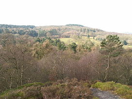
 A view from Bilberry Hill over Rosehill Road and the Birmingham Municipal Golf Course towards Beacon Hill. Bilberry bushes can be seen in the foreground. | |
| Highest point | |
| Elevation | 260 m (850 ft)[1] |
| Prominence | 116 m (381 ft)[2] |
| Geography | |
 | |
| Location | Worcestershire, UK |
| Parent range | Lickey Hills |
Bilberry Hill is one of the Lickey Hills in northern Worcestershire, England, 10.3 miles (16.6 kilometres) southwest of Birmingham and 24 miles (39 kilometres) northeast of Worcester. It stands above and to the west of the village of Cofton Hackett, and is part of the Lickey Hills Country Park.
The three hilltops comprising The Lickeys—Bilberry Hill, Rednal Hill and Cofton Hill—form the northern extremity of the Lickey Ridge, a formation of hard quartzite. Views over Birmingham and the surrounding countryside can be seen from the top of these hills.
The hill is named after the tracts of Bilberry (Vaccinium myrtillus) bushes that cover the hill, between the pathways. Local people have been cropping the bushes of their fruit each autumn for hundreds of years to make jams, preserves or apple and bilberry pies.
