Biloxi Bay Bridge | |
|---|---|
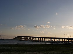
 Biloxi Bay Bridge from the shore. | |
| Coordinates | 30°24′6″N 88°50′58″W / 30.40167°N 88.84944°W |
| Carries | 6 lanes of |
| Crosses | Biloxi Bay |
| Locale | Biloxi and Ocean Springs, Mississippi |
| Maintained by | MDOT |
| Characteristics | |
| Width | 129 ft (39.3 m) |
| Height | 95 ft (28.9 m) |
| History | |
| Opened | November 1, 2007 |
| Location | |
 | |

The Biloxi Bay Bridge is a bridge in the U.S. state of Mississippi which carries U.S. Route 90 (US 90) over Biloxi Bay between Biloxi and Ocean Springs. Though the bridge's ballast and accompanying railroad track was heavily damaged by Hurricane Katrina in August 2005, the structure remained and subsequently underwent major repairs.[1] It reopened to traffic on November 1, 2007. The span carries 6 lanes of traffic as well as a 12-foot (3.7 m) path for pedestrians and bicyclists on the Gulf side of the bridge.

- ^ Reginald DesRoches, PhD, ed. (2006). Hurricane Katrina: Performance of Transportation Systems. Reston, VA: ASCE, TCLEE. ISBN 9780784408797. Archived from the original on March 3, 2014.
