Back Blayney (rehiyon) CEB Blayney Shire German Comté de Blayney French Contea di Blayney Italian Blayney Shire Council Dutch Blayney Shire Swedish
| Blayney Shire New South Wales | |||||||||||||||
|---|---|---|---|---|---|---|---|---|---|---|---|---|---|---|---|
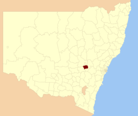
 Location in New South Wales | |||||||||||||||
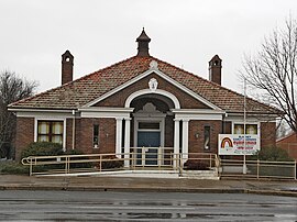
 Council Chambers, Blayney | |||||||||||||||
| Coordinates | 33°32′S 149°15′E / 33.533°S 149.250°E | ||||||||||||||
| Population |
| ||||||||||||||
| • Density | 4.7587/km2 (12.325/sq mi) | ||||||||||||||
| Area | 1,525 km2 (588.8 sq mi) | ||||||||||||||
| Mayor | Bruce Reynolds (Independent | ||||||||||||||
| Council seat | Blayney[3] | ||||||||||||||
| Region | Central West | ||||||||||||||
| State electorate(s) | Bathurst | ||||||||||||||
| Federal division(s) | Calare | ||||||||||||||
 | |||||||||||||||
| Website | Blayney Shire | ||||||||||||||
| |||||||||||||||
Blayney Shire is a local government area in the Central West region of New South Wales, Australia. The Shire is located adjacent to the Mid-Western Highway and the Main Western railway line, and is centred on the town of Blayney.
Blayney Shire consists of approximately 1,600 square kilometres (620 sq mi) of well watered, gently undulating to hilly country and the climate is partially suitable for cool climate crops and trees. There is also significant mining industry in the shire.
- ^ Australian Bureau of Statistics (27 June 2017). "Blayney (A)". 2016 Census QuickStats. Retrieved 7 July 2017.
- ^ "3218.0 – Regional Population Growth, Australia, 2017-18". Australian Bureau of Statistics. 27 March 2019. Retrieved 27 March 2019. Estimated resident population (ERP) at 30 June 2018.
- ^ "Blayney Shire Council". Division of Local Government. Retrieved 28 November 2006.