Back Blue Mountains Afrikaans Monts Azuls (Australia) AN الجبال الزرقاء (أستراليا) Arabic Блакітныя горы (Аўстралія) Byelorussian Блу Маунтънс (планини, Австралия) Bulgarian Muntanyes Blaves d'Austràlia Catalan Modré hory Czech Mynyddoedd Glas Welsh Blue Mountains Danish Blue Mountains (Australien) German
| Blue Mountains New South Wales | |||||||||||||||
|---|---|---|---|---|---|---|---|---|---|---|---|---|---|---|---|
 The Three Sisters sandstone rock formation, one of the region's best-known attractions | |||||||||||||||
| Coordinates | 33°43′05″S 150°18′38″E / 33.71806°S 150.31056°E[1] | ||||||||||||||
| Population | 30,049 (UCL 2021)[2] | ||||||||||||||
| Area | 11,400 km2 (4,401.6 sq mi) | ||||||||||||||
| Location | 50 km (31 mi) NW of Sydney CBD | ||||||||||||||
| LGA(s) | Blue Mountains | ||||||||||||||
| State electorate(s) | |||||||||||||||
| Federal division(s) | |||||||||||||||
| |||||||||||||||
| Blue Mountains Range | |
|---|---|
| Blue Mountains | |
 The characteristic blue haze, as seen in the Jamison Valley | |
| Highest point | |
| Peak | unnamed peak, north-east of Lithgow |
| Elevation | 1,189 m (3,901 ft) AHD |
| Dimensions | |
| Length | 96 km (60 mi) NW/SE[3] |
| Geography | |
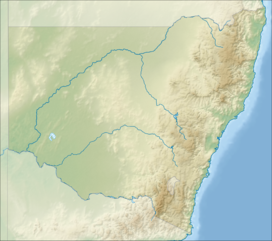
Location of the Blue Mountains Range in New South Wales | |
| Country | Australia |
| State | New South Wales |


The Blue Mountains are a mountainous region and a mountain range located in New South Wales, Australia. The region is considered to be part of the western outskirts of the Greater Sydney area. The region borders on Sydney's main metropolitan area, its foothills starting about 50 kilometres (31 mi) west of centre of the state capital, close to Penrith.[4] The public's understanding of the extent of the Blue Mountains is varied, as it forms only part of an extensive mountainous area associated with the Great Dividing Range.[5] As defined in 1970, the Blue Mountains region is bounded by the Nepean and Hawkesbury rivers in the east, the Coxs River and Lake Burragorang to the west and south, and the Wolgan and Colo rivers to the north.[6] Geologically, it is situated in the central parts of the Sydney Basin.[7]
The Blue Mountains Range comprises a range of mountains, plateau escarpments extending off the Great Dividing Range about 4.8 kilometres (3.0 mi) northwest of Wolgan Gap in a generally southeasterly direction for about 96 kilometres (60 mi), terminating at Emu Plains. For about two-thirds of its length it is traversed by the Great Western Highway, the Main Western railway line and the proposed Blue Mountains tunnel.[8] Several established towns are situated on its heights, including Katoomba, Blackheath, Mount Victoria, and Springwood. The range forms the watershed between Coxs River to the south and the Grose and Wolgan rivers to the north.[3] The range contains the Explorer Range and the Bell Range.[9]
Once considered impassable by settlers, the 1813 expedition by Blaxland, Wentworth and Lawson opened up the interior to British settlement. Today, the Blue Mountains area includes the local government area of the City of Blue Mountains. Since the early 2010s, the region's biodiversity and infrastructure has been severely affected by massive bushfires of unprecedented size and impact.[10] In 2018 8.4 million people visited the Blue Mountains.[11] The Blue Mountains and Southern Highlands Basalt Forests is a prominent forest community within the ecoregion.[12]
- ^ "Mount Piddington". Geographical Names Register (GNR) of NSW. Geographical Names Board of New South Wales. Retrieved 6 May 2015.
- ^ Australian Bureau of Statistics (28 June 2022). "Blue Mountains (urban centre and locality)". Australian Census 2021.
- ^ a b "Blue Mountains Range". Geographical Names Register (GNR) of NSW. Geographical Names Board of New South Wales. Retrieved 6 May 2015.
- ^ Gregory's New South Wales State Road Map, Map 220, 11th Edition, Gregory's Publishing Company
- ^ Cite error: The named reference
Macqueenwas invoked but never defined (see the help page). - ^ "Blue Mountains". Geographical Names Register (GNR) of NSW. Geographical Names Board of New South Wales.
- ^ "Blue Mountains (New South Wales)" (Map). Google Maps. Retrieved 3 August 2024.
- ^ "Australia's longest tunnel will save commuters "up to 30 minutes"". 16 May 2022.
- ^ "Map of Bell Range, NSW". Bonzle Digital Atlas of Australia. Retrieved 6 May 2015.
- ^ Cox, Lisa; Evershed, Nick (16 January 2020). "'It's heart-wrenching': 80% of Blue Mountains and 50% of Gondwana rainforests burn in bushfires". The Guardian. ISSN 0261-3077. Retrieved 18 January 2020.
- ^ Curtin, Jennie (19 August 2019). "More than eight million visited Blue Mountains National Park last year". Blue Mountains Gazette. Archived from the original on 2 October 2019. Retrieved 3 July 2022.
- ^ Blue Mountains Basalt Forest in the Sydney Basin Bioregion - profile Office of Environment & Heritage by NSW Government. Retrieved 9 September 2022.
