Back كوبرى الميه الزرقا ARZ Blue Water Bridge German Blue Water Bridge French 블루워터브리지 Korean Blue Water Bridge Dutch Ponte Blue Water Portuguese Most Blue Water Serbo-Croatian Blue Water Bridge Swedish 藍水大橋 Chinese
Blue Water Bridge | |
|---|---|
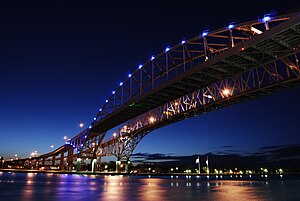
 Blue Water Bridge, newer bridge in foreground | |
| Coordinates | 42°59′55″N 82°25′25″W / 42.99861°N 82.42361°W |
| Carries | 6 lanes of |
| Crosses | St. Clair River |
| Locale | Port Huron, Michigan and Point Edward, Ontario |
| Official name | Blue Water Bridge |
| Maintained by | MDOT and Federal Bridge Corporation |
| Characteristics | |
| Design | Cantilever truss (westbound) Continuous tied arch (eastbound) |
| Total length | 6,178 ft (1,883 m) (westbound) 6,109 ft (1,862 m) (eastbound) |
| Width | 38 ft (12 m) (westbound) 51 ft (16 m) (eastbound) |
| Height | 210 ft (64 m) (westbound) 233 ft (71 m) (eastbound) |
| Longest span | 871 ft (265 m) (westbound) 922 ft (281 m) (eastbound) |
| Clearance below | 152 ft (46 m) (westbound) 155 ft (47 m) (eastbound) |
| History | |
| Opened | October 10, 1938 (westbound) July 22, 1997 (eastbound) |
| Statistics | |
| Daily traffic |
|
| Toll | Cars: US$3.00 or C$4.00 (to Canada) and US$3.25 or C$4.25 (to US) As of January 28, 2020[update]
Extra axles: US$3.00 or C$4.00 (to Canada) and US$3.25 or C$4.25 (to US) Trucks & buses: US$3.25 or C$4.25 per axle (to Canada) and US$3.50 or C$4.50 per axle (to US). C$4.25 per axle with Prepaid Account (to US). |
| Location | |
 | |


The Blue Water Bridge is a twin-span international bridge across the St. Clair River that links Port Huron, Michigan, United States, and Point Edward, Ontario, Canada. The Blue Water Bridge connects Highway 402 in Ontario with both Interstate 69 (I-69) and Interstate 94 (I-94) in Michigan.
- ^ "Blue Water Bridge". Federal Bridge Corporation. Archived from the original (XLS) on November 14, 2016. Retrieved November 14, 2016.