Back Бароу на Фърнис (община) Bulgarian Barrow-in-Furness District CEB Bwrdeistref Barrow-in-Furness Welsh Borough of Barrow-in-Furness German Municipio de Barrow-in-Furness Spanish Barrow-in-Furness (district) French Borough of Barrow-in-Furness Italian 배로인퍼니스구 Korean Barrow-in-Furness Dutch Borough of Barrow-in-Furness NB
Borough of Barrow-in-Furness | |
|---|---|
 Skyline of Barrow-in-Furness | |
|
| |
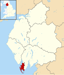
 Shown within Cumbria | |
| Coordinates (Barrow-In-Furness Town Centre): 54°06′42″N 3°13′34″W / 54.11155°N 3.22614°W | |
| Sovereign state | United Kingdom |
| Constituent country | England |
| Region | North West England |
| Ceremonial county | Cumbria |
| Historic county | Lancashire |
| Founded | 1 April 1974 |
| Abolished | 31 March 2023 |
| Admin. HQ | Barrow Town Hall, Barrow-in-Furness |
| Government | |
| • Type | Barrow-in-Furness Borough Council |
| • Leadership: | Alternative – Sec.31 |
| Area | |
• Total | 30.08 sq mi (77.90 km2) |
| Population (2021) | |
• Total | 67,375 |
| • Density | 2,200/sq mi (860/km2) |
| Time zone | UTC+0 (Greenwich Mean Time) |
| • Summer (DST) | UTC+1 (British Summer Time) |
| Area code | 01229 |
| ONS code | 16UC (ONS) E07000027 (GSS) |
| Ethnicity (2021) | 95.7% White British 1.4% White Other 1.4% Asian 0.8% Mixed Race 0.4% Black 0.4 Other |
| Website | www |
Barrow-in-Furness was a local government district with borough status in Cumbria, England. It was named after its main town, Barrow-in-Furness. Other settlements included Dalton-in-Furness and Askam-in-Furness. It was the smallest district in Cumbria, but the most densely populated, with 924 people per square kilometre. The population was 71,980 in 2001,[1] reducing to 69,087 at the 2011 Census.[2]
In July 2021 the Ministry of Housing, Communities and Local Government announced that in April 2023, Cumbria would be reorganised into two unitary authorities.[3] On 1 April 2023, Barrow-in-Furness Borough Council was abolished and its functions transferred to the new authority Westmorland and Furness, which also covers the former districts of Eden and South Lakeland.[4]
- ^ UK Census (2001). "Local Area Report – Barrow-in-Furness Local Authority (E07000027)". Nomis. Office for National Statistics. Retrieved 27 March 2021.
- ^ UK Census (2011). "Local Area Report – Barrow-in-Furness Local Authority (E07000027)". Nomis. Office for National Statistics. Retrieved 27 March 2021.
- ^ "Next steps for new unitary councils in Cumbria, North Yorkshire and Somerset". GOV.UK. 21 July 2021. Retrieved 16 March 2024.
- ^ "Future for Cumbrian councils". Local Government Reorganisation. Archived from the original on 2 April 2023. Retrieved 16 March 2024.

