Back بوسكوپ ARZ Boskoop Catalan Boskoop CEB Boskoop (Niederlande) German Boskoop Esperanto Boskoop Spanish Boskoop Basque بوسکوپ Persian Boskoop (Pays-Bas) French Բոսկոպ Armenian
Boskoop | |
|---|---|
Town and former municipality | |
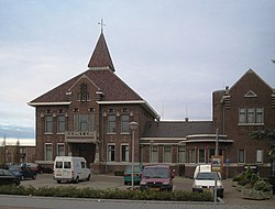
 Former Boskoop city hall | |
| Coordinates: 52°4′N 4°39′E / 52.067°N 4.650°E | |
| Country | Netherlands |
| Province | South Holland |
| Municipality | Alphen aan den Rijn |
| Area | |
• Total | 7.29 km2 (2.81 sq mi) |
| • Land | 5.91 km2 (2.28 sq mi) |
| • Water | 1.39 km2 (0.54 sq mi) |
| Elevation | −2 m (−7 ft) |
| Population (2021)[3] | |
• Total | 16,325 |
| • Density | 2,200/km2 (5,800/sq mi) |
| Time zone | UTC+1 (CET) |
| • Summer (DST) | UTC+2 (CEST) |
| Postcode | 2770–2771 |
| Area code | 0172 |


Boskoop (Dutch pronunciation: [ˈbɔskoːp] ⓘ) is a town in the province of South Holland. It was a separate municipality until it merged into Alphen aan den Rijn in 2014. The town had a population of 15,050 in 2012 and covers an area of 7.29 km2 (2.81 sq mi) of which 1.39 km2 (0.54 sq mi) is water. It's the world's biggest joined floriculture area.
Boskoop is famous for its nurseries, particularly woody plant and perennial nurseries, of which some 774 are situated on long stretches of land, divided by narrow canals. Before World War II almost all transport was conducted using narrow boats. A few exceptionally high footbridges crossing some of the broader (main) canals remain from these days. Between the World Wars the transition was made from fruit culture to decorative garden plants and trees. As a source of technical knowledge about the art of growing decorative plants, Boskoop remains world-renowned and unique.
The name "Boskoop" has been given to an apple cultivar (Belle de Boskoop) which is widely distributed in the Low Countries, to a grape variety (Boskoop Glory) and also to a variety of Calluna (Boskoop) and Weigela (Boskoop Glory) and blackcurrant ("Boskoop Giant").
- ^ "Kerncijfers wijken en buurten" [Key figures for neighbourhoods]. CBS Statline (in Dutch). CBS. 11 December 2013. Retrieved 14 January 2014.
- ^ "Postcodetool for 2771EK". Actueel Hoogtebestand Nederland (in Dutch). Het Waterschapshuis. Retrieved 15 July 2013.
- ^ "Kerncijfers wijken en buurten 2021". Central Bureau of Statistics. Retrieved 2 May 2022.


