Back خليج بوثينيا Arabic Badea de Botnia AST بوتنی کؤرفزی AZB Badia de Bòtnia Catalan Bottenbugten Danish Bottenwiek German Perämeri Esperanto Bahía de Botnia Spanish Perämeri Estonian Botniako badia Basque
| Bothnian Bay | |
|---|---|
| Bay of Bothnia | |
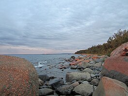
 The rocky shoreline of Ohtakari, in the southeast of the bay | |
| Location | Fennoscandia |
| Coordinates | 65°N 023°E / 65°N 23°E |
| Type | Sea |
| Primary outflows | Bothnian Sea |
| Catchment area | 260,675 km2 (100,647 sq mi) |
| Basin countries | Finland, Norway, and Sweden |
| Surface area | 36,800 km2 (14,200 sq mi) |
| Average depth | 43 m (141 ft) |
| Max. depth | 147 m (482 ft) |
| Water volume | 1,490 km3 (360 cu mi) |
| Frozen | 110–190 days annually |
The Bothnian Bay or Bay of Bothnia (Swedish: Bottenviken; Finnish: Perämeri) is the northernmost part of the Gulf of Bothnia, which is in turn the northern part of the Baltic Sea. The land holding the bay is still rising after the weight of ice-age glaciers has been removed, and within 2,000 years the bay will be a large freshwater lake since its link to the south Kvarken is mostly less than 20 metres (66 ft) deep. The bay today is fed by several large rivers, and is relatively unaffected by tides, so has low salinity. It freezes over each year for up to six months. Compared to other parts of the Baltic, it has little plant or animal life.
