Back بوزيمان Arabic بوزيمان ARZ بوزمان، مونتانا AZB Бозман (Мантана) Byelorussian Боузман Bulgarian Bozeman Catalan Бозмен (Монтана) CE Bozeman CEB Bozeman Czech Bozeman, Montana Welsh
Bozeman | |
|---|---|
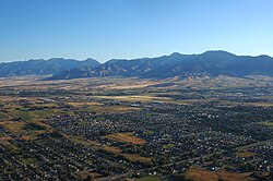
 Aerial view of Bozeman | |
|
| |
 Location of Bozeman, Montana | |
| Coordinates: 45°41′08″N 111°01′30″W / 45.68556°N 111.02500°W[1] | |
| Country | United States |
| State | Montana |
| County | Gallatin |
| Founded | August 9, 1864 |
| Named for | John Bozeman |
| Government | |
| • Type | City commission/City manager |
| • Mayor | Terry Cunningham[2] |
| Area | |
• City | 20.91 sq mi (54.16 km2) |
| • Land | 20.86 sq mi (54.04 km2) |
| • Water | 0.05 sq mi (0.13 km2) |
| Elevation | 4,817 ft (1,468 m) |
| Population (2020) | |
• City | 53,293 |
• Estimate (2022)[5] | 56,123 |
| • Density | 2,554.43/sq mi (986.26/km2) |
| • Metro | 118,960 |
| • Demonym | Bozemanite |
| Time zone | UTC−7 (MST) |
| • Summer (DST) | UTC−6 (MDT) |
| ZIP codes | 59715, 59717-59719, 59718, 59771-59772 |
| Area code | 406 |
| FIPS code | 30-08950 |
| GNIS feature ID | 2409889[4] |
| Website | www.bozeman.net |
| [citation needed] | |
Bozeman (/ˈboʊzmən/ BOHZ-mən) is a city in and the county seat of Gallatin County, Montana, United States. Located in southwest Montana, the 2020 census put Bozeman's population at 53,293 making it the fourth-largest city in Montana.[7] It is the principal city of the Bozeman, Montana, Micropolitan Statistical Area, consisting of all of Gallatin County with a population of 118,960.[6] It is the fastest growing micropolitan statistical area in the United States in 2018, 2019 and 2020,[8][disputed – discuss] as well as the second-largest of all Montana's statistical areas.[9][10]
- ^ "Bozeman, Montana". Geographic Names Information System. United States Geological Survey, United States Department of the Interior.
- ^ Shelly, Nora (January 10, 2024). "New year, new mayor: Cunningham, Morrison and Madgic sworn into office". Bozeman Daily Chronicle.
- ^ "ArcGIS REST Services Directory". United States Census Bureau. Retrieved September 5, 2022.
- ^ a b U.S. Geological Survey Geographic Names Information System: Bozeman, Montana
- ^ Cite error: The named reference
USCensusEst2022was invoked but never defined (see the help page). - ^ a b "Metropolitan and Micropolitan Statistical Areas". The United States Census Bureau. Retrieved November 5, 2021.
- ^ "U.S. Census website". United States Census Bureau. Retrieved November 2, 2021.
- ^ "Economic Strength Rankings - Micropolitan Areas". policom.com. Archived from the original on November 2, 2017. Retrieved January 24, 2021.
- ^ "Archived copy". Archived from the original on April 1, 2013. Retrieved June 5, 2013.
{{cite web}}: CS1 maint: archived copy as title (link) - ^ "CENSUS 2010 - STATE and COUNTY POPULATION SUMMARY" (PDF). Bloximages.chicago2.vip.townnews.com. Archived (PDF) from the original on March 28, 2014. Retrieved March 4, 2022.


