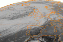
 METEOSAT satellite image of the Braer Storm near peak intensity on 10 January 1993 | |
| Meteorological history | |
|---|---|
| Formed | 8 January 1993 |
| Dissipated | 17 January 1993 |
| Extratropical cyclone | |
| Highest winds | 194 km/h (121 mph) |
| Lowest pressure | 914 hPa (mbar); 26.99 inHg (Strongest extratropical cyclone over North Atlantic Ocean) |
| Overall effects | |
| Fatalities | None |
| Areas affected | North Atlantic, Greenland, Iceland, Western Europe |
Part of the 1992–93 European windstorm season | |
The Braer Storm was the most intense extratropical cyclone ever recorded over the northern Atlantic Ocean. Developing as a weak frontal wave on 8 January 1993, the system moved rapidly northeast. The combination of the absorption of a second low-pressure area to its southeast, a stronger than normal sea surface temperature differential along its path, and the presence of a strong jet stream aloft led to a rapid strengthening of the storm, with its central pressure falling to an estimated 914 hPa (914.0 mb; 26.99 inHg) on 10 January. Its strength was well predicted by forecasters in the United Kingdom, and warnings were issued before the low initially developed.
Gale-force winds covered the far northern Atlantic between Western Europe and Atlantic Canada, due to the intensity of this storm, with hurricane-force winds confined near its centre of circulation. After reaching its peak intensity, the system weakened as it moved into the far northeast Atlantic, dissipating by 17 January. This storm caused severe blizzards across much of Scotland. It also led to the final breakup of the oil tanker MV Braer, from which the storm derived its name; she had been stranded in rocks off the Shetland Islands by a previous storm nearly a week beforehand.
