Back برجتون Arabic برجتون ARZ بریجتون، میزوری AZB Bridgeton (Missouri) Catalan Бриджтон (Миссури) CE Bridgeton (lungsod sa Tinipong Bansa, Missouri) CEB Bridgeton, Missouri Welsh Bridgeton (Missouri) German Bridgeton (Misuri) Spanish Bridgeton (Missouri) Basque
Bridgeton, Missouri | |
|---|---|
 Welcome sign, Bridgeton, July 2016 | |
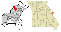
 Location of Bridgeton, Missouri | |
| Coordinates: 38°45′26″N 90°25′4″W / 38.75722°N 90.41778°W | |
| Country | United States |
| State | Missouri |
| County | St. Louis |
| Government | |
| • Mayor | Randy Hein |
| Area | |
• Total | 15.24 sq mi (90.00 km2) |
| • Land | 14.55 sq mi (37.69 km2) |
| • Water | 0.69 sq mi (1.77 km2) |
| Elevation | 541 ft (165 m) |
| Population (2020) | |
• Total | 11,445 |
| • Density | 786.44/sq mi (303.65/km2) |
| Time zone | UTC-6 (Central (CST)) |
| • Summer (DST) | UTC-5 (CDT) |
| ZIP code | 63044[3] |
| Area code(s) | 314/557 |
| FIPS code | 29-08398[4] |
| GNIS feature ID | 2393417[2] |
| Website | www |
Bridgeton is a second-ring suburb of Greater St. Louis in northwestern St. Louis County, Missouri, United States. Bridgeton is located at the intersection of the St. Louis outer belt and I-70. Bridgeton serves as the primary transport hub within Greater St. Louis. The population at the 2020 census was 11,445.[5] Portions of St. Louis Lambert International Airport are within Bridgeton.[6] The town is featured in the documentary Atomic Homefront, which covers the effects of radioactive waste stored in the nearby West Lake Landfill site.
- ^ "ArcGIS REST Services Directory". United States Census Bureau. Retrieved August 28, 2022.
- ^ a b U.S. Geological Survey Geographic Names Information System: Bridgeton, Missouri
- ^ "Bridgeton MO ZIP Code". zipdatamaps.com. 2023. Retrieved January 26, 2023.
- ^ "U.S. Census website". United States Census Bureau. Retrieved January 31, 2008.
- ^ "United States Census Bureau". Retrieved February 3, 2022.
- ^ "Bridgeton city, Missouri[permanent dead link]." U.S. Census Bureau. Retrieved on June 9, 2009.