Back مقاطعة بوكنغهام (فيرجينيا) Arabic Buckingham County, Virginia BAR Бъкингам (окръг, Вирджиния) Bulgarian বাকিংহাম কাউন্টি, ভার্জিনিয়া BPY Buckingham Gông (Virginia) CDO Бакингхем (гуо, Виргини) CE Buckingham County CEB Buckingham County, Virginia Welsh Buckingham County German Condado de Buckingham Spanish
Buckingham County | |
|---|---|
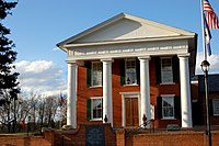
 Buckingham County Courthouse | |
 Location within the U.S. state of Virginia | |
 Virginia's location within the U.S. | |
| Coordinates: 37°34′N 78°32′W / 37.57°N 78.53°W | |
| Country | |
| State | |
| Founded | 1761 |
| Named for | Duke of Buckingham |
| Seat | Buckingham |
| Largest town | Dillwyn |
| Area | |
• Total | 584 sq mi (1,510 km2) |
| • Land | 580 sq mi (1,500 km2) |
| • Water | 3.9 sq mi (10 km2) 0.7% |
| Population (2020) | |
• Total | 16,824 |
| • Density | 29/sq mi (11/km2) |
| Time zone | UTC−5 (Eastern) |
| • Summer (DST) | UTC−4 (EDT) |
| Congressional district | 5th |
| Website | www |
Buckingham County is a rural United States county located in the Commonwealth of Virginia, and containing the geographic center of the state.[citation needed] Buckingham County is part of the Piedmont region of Virginia, and the county seat is Buckingham.[1]
Buckingham County was created in 1761 from the southeastern portion of Albemarle County and was predominantly farmland. The county was probably named in honor of the Duke of Buckingham, though the precise origin is uncertain. Several changes were made to the borders, until the existing boundaries were established in 1860.
As of the 2020 census, the county population was 16,824.[2]
- ^ "Find a County". National Association of Counties. Archived from the original on May 31, 2011. Retrieved June 7, 2011.
- ^ "Buckingham County, Virginia". United States Census Bureau. Retrieved January 30, 2022.

