Back مقاطعة بونغو Arabic Provincie Bungo Czech Provinz Bungo German Provincia de Bungo Spanish ولایت بونگو Persian Bungo (province) French Provincia de Bungo Galician בונגו (מחוז) HE Provinsi Bungo ID Bungo (provincia) Italian

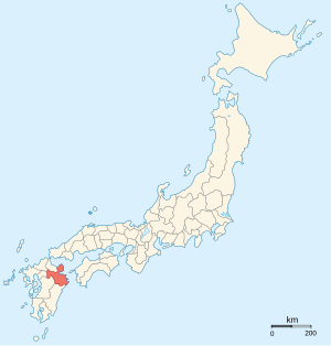
Bungo Province (豊後国, Bungo-no kuni) was a province of Japan in the area of eastern Kyūshū, corresponding to most of modern Ōita Prefecture, except what is now the cities of Nakatsu and Usa.[1] Bungo bordered on Hyūga to the south, Higo and Chikugo to the west, and Chikuzen and Buzen to the north. Its abbreviated form was Hōshū (豊州), although it was also called Nihō (二豊). In terms of the Gokishichidō system, Bungo was one of the provinces of the Saikaidō circuit. Under the Engishiki classification system, Bungo was ranked as one of the "superior countries" (上国) in terms of importance, and one of the "far countries" (遠国) in terms of distance from the capital.

- ^ Nussbaum, Louis-Frédéric. (2005). "Bungo" in Japan Encyclopedia, p. 411, p. 411, at Google Books.