17°36′49″N 121°41′29″E / 17.61361°N 121.69139°E
Buntun Bridge | |
|---|---|
 | |
| Coordinates | 17°36′49″N 121°41′29″E / 17.6136°N 121.6914°E |
| Carries | 2 lanes of |
| Crosses | Cagayan River |
| Locale | Tuguegarao City, Cagayan (North) Solana, Cagayan (South) |
| Official name | Buntun Bridge |
| Other name(s) | Talletay ta Buntun |
| Maintained by | Department of Public Works and Highways – Cagayan 3rd District Engineering Office |
| Characteristics | |
| Design | Steel truss bridge[1] |
| Material | Steel, Concrete, Asphalt |
| Total length | 1,369 m (4,491 ft)[a] |
| Width | 9.60 m (31 ft)[2] |
| Height | 37 m (121 ft) |
| No. of spans | 14 |
| Load limit | 18 t (18,000 kg) |
| Clearance above | 6 m (20 ft) |
| History | |
| Constructed by | Philippine National Construction Corporation |
| Construction start | December 11, 1960[1] |
| Construction end | May 10, 1969 |
| Opened | June 1, 1969 |
| Statistics | |
| Toll | No |
| Location | |
 | |
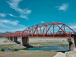
Buntun Bridge (Itawit: Talletay ta Buntun; Ilocano: Rangtáy ti Buntun; Filipino: Tulay ng Buntun) is a river bridge that stretches from Tuguegarao City to Solana in Cagayan and spans the Cagayan River, the largest river basin in the Philippines.[3] It forms part of the Santiago–Tuguegarao Road (designated as N51 by the Department of Public Works and Highways highway routing system), a major junction of the Pan-Philippine Highway. It was the longest bridge in the Philippines upon its opening in 1969, surpassed in 1973 by the San Juanico Bridge.
A popular belief is that the bridge is long enough for a person to recite the entire Philippine National Anthem while traversing.[4]
- ^ a b De Yro, Benjie (October 29, 2016). "Buntun, the bridge 3 presidents built". The Northern Forum. Retrieved October 29, 2016.
- ^ "Road and Bridge Inventory". Department of Public Works and Highways. Retrieved March 6, 2022.
- ^ "Buntun Bridge". lakbaypinas.ph. Archived from the original on April 16, 2013. Retrieved January 27, 2022.
- ^ "Buntun Bridge, the longest river bridge in the Philippines". www.dangerousroads.org.
Cite error: There are <ref group=lower-alpha> tags or {{efn}} templates on this page, but the references will not show without a {{reflist|group=lower-alpha}} template or {{notelist}} template (see the help page).
