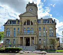
Back مقاطعة بتلر (أوهايو) Arabic بوتلر بؤلگهسی، اوهایو AZB Butler County, Ohio BAR Бътлър (окръг, Охайо) Bulgarian বাটরার কাউন্টি, ওহাইও BPY Butler Gông (Ohio) CDO Butler County (kondado sa Tinipong Bansa, Ohio) CEB Butler County, Ohio Welsh Butler County (Ohio) Danish Butler County (Ohio) German
Butler County | |
|---|---|
 | |
 Location within the U.S. state of Ohio | |
 Ohio's location within the U.S. | |
| Coordinates: 39°26′N 84°35′W / 39.44°N 84.58°W | |
| Country | |
| State | |
| Founded | May 1, 1803[1] |
| Named for | General Richard Butler |
| Seat | Hamilton |
| Largest city | Hamilton |
| Area | |
• Total | 470 sq mi (1,200 km2) |
| • Land | 467 sq mi (1,210 km2) |
| • Water | 3.1 sq mi (8 km2) 0.7% |
| Population (2020) | |
• Total | 390,357 |
• Estimate (2023) | 393,043 |
| • Density | 830/sq mi (320/km2) |
| Time zone | UTC−5 (Eastern) |
| • Summer (DST) | UTC−4 (EDT) |
| Congressional district | 8th |
| Website | bcohio |
Butler County is a county located in the southwestern part of the U.S. state of Ohio. As of the 2020 census, the population was 390,357.[2] Its county seat and largest city is Hamilton.[3] It is named for General Richard Butler, who died in 1791 during St. Clair's Defeat.[4] Located along the Great Miami River, it is also home to Miami University, a public university founded in 1809. Butler County is part of the Cincinnati, OH-KY-IN Metropolitan Statistical Area. The majority of the county is in District 52 of the State House.
- ^ "Ohio County Profiles: Butler County" (PDF). Ohio Department of Development. Archived from the original (PDF) on June 21, 2007. Retrieved April 28, 2007.
- ^ "State & County QuickFacts". United States Census Bureau. Retrieved July 6, 2022.
- ^ "Find a County". National Association of Counties. Archived from the original on May 31, 2011. Retrieved June 7, 2011.
- ^ Rennick, Robert M. (August 28, 2013). Kentucky Place Names. University Press of Kentucky. pp. 103–. ISBN 9780813144016. Retrieved September 6, 2014.

