Back بوتي (مونتانا) Arabic بيوت مونتانا ARZ Butte AVK بوت، مونتانا AZB Б’ют (горад) Byelorussian Бют Bulgarian Butte (Montana) Breton Butte-Silver Bow Catalan Бьют (Монтана) CE Butte (kapital sa kondado sa Tinipong Bansa, Montana) CEB
Butte | |
|---|---|
| Butte-Silver Bow | |
 Clockwise, left to right: view of uptown Butte from west; Our Lady of the Rockies; Curtis Music Hall; aerial view of the Berkeley Pit; mine headframe; and the Finlen Hotel | |
| Nickname: Butte America | |
| Motto: The Richest Hill on Earth | |
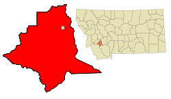
 Map of Silver Bow County showing the city of Butte in red and Walkerville in gray | |
| Coordinates: 45°54′08″N 112°39′24″W / 45.90222°N 112.65667°W | |
| Country | United States |
| State | Montana |
| County | Silver Bow |
| Settled | 1864 |
| Area | |
• Total | 716.34 sq mi (1,855.32 km2) |
| • Land | 715.76 sq mi (1,853.80 km2) |
| • Water | 0.59 sq mi (1.52 km2) |
| Elevation | 5,824 ft (1,775 m) |
| Population (2020) | |
• Total | 34,494 |
| • Density | 48.19/sq mi (18.61/km2) |
| Time zone | UTC−7 (MST) |
| • Summer (DST) | UTC−6 (MDT) |
| ZIP code | 59701, 59702, 59703, 59707, 59750 |
| Area code | 406 |
| FIPS code | 30-11397 |
| GNIS feature ID | 2409651[2] |
| Website | www |
Butte (/bjuːt/ BEWT) is a consolidated city-county and the county seat of Silver Bow County, Montana, United States. In 1977, the city and county governments consolidated to form the sole entity of Butte-Silver Bow. The city covers 718 square miles (1,860 km2), and, according to the 2020 census, has a population of 34,494, making it Montana's fifth-largest city. It is served by Bert Mooney Airport with airport code BTM.
Established in 1864 as a mining camp in the northern Rocky Mountains on the Continental Divide, Butte experienced rapid development in the late 19th century, and was Montana's first major industrial city.[3] In its heyday between the late 19th and early 20th centuries, it was one of the largest copper boom towns in the American West. Employment opportunities in the mines attracted surges of Asian and European immigrants, particularly the Irish;[4] as of 2017, Butte has the largest population of Irish Americans per capita of any U.S. city.
Butte was also the site of various historical events involving its mining industry and active labor unions and socialist politics, the most famous of which was the labor riot of 1914. Despite the dominance of the Anaconda Copper Mining Company, Butte was never a company town. Other major events in the city's history include the 1917 Speculator Mine disaster, the largest hard rock mining disaster in world history.
Over the course of its history, Butte's mining and smelting operations generated more than $48 billion worth of ore, but also resulted in numerous environmental implications for the city: The upper Clark Fork River, with headwaters at Butte, is the largest Superfund site in the nation, and the city is also home to the Berkeley Pit. In the late 20th century, the EPA instated cleanup efforts, and the Butte Citizens Technical Environmental Committee was established in 1984. In the 21st century, efforts to interpret and preserve Butte's heritage are addressing both the town's historical significance and the continuing importance of mining to its economy and culture. The city's Uptown Historic District, on the National Register of Historic Places, is one of the largest National Historic Landmark Districts in the U.S., containing nearly 6,000 contributing properties. The city is also home to Montana Technological University, a public engineering and technical university.
- ^ "ArcGIS REST Services Directory". United States Census Bureau. Retrieved September 5, 2022.
- ^ a b U.S. Geological Survey Geographic Names Information System: Butte, Montana
- ^ Cite error: The named reference
historyculturewas invoked but never defined (see the help page). - ^ McMahon, Paul (November 20, 1988). "Electricity sparked Montana city's rise". The Bulletin. (Bend, Oregon). p. B4.

