Back Centre cerimonial indígena de Caguana Catalan Parque Ceremonial de Indigena Caguana CEB Centro ceremonial indígena de Caguana Spanish Caguana (sito archeologico) Italian
Caguana Ceremonial Ball Courts Site | |
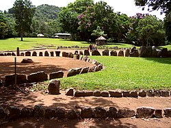
 Taíno ball courts at Caguana Site | |
| Location | Highway 111, Km 12.3 Utuado, Puerto Rico |
|---|---|
| Coordinates | 18°17′42″N 66°46′52″W / 18.294870°N 66.780974°W |
| Area | 7 acres (2.8 ha)[2] |
| Built | Around 1270 AD |
| MPS | Ball Court/Plaza Sites of Puerto Rico and the U.S. Virgin Islands |
| NRHP reference No. | 92001671[1] |
| RNSZH No. | 2000-(RC)-22-JP-SH |
| Significant dates | |
| Added to NRHP | December 17, 1992 |
| Designated NHL | November 4, 1993[3] |
| Designated RNSZH | March 15, 2001 |
The Caguana Ceremonial Ball Courts Site (often referred to as Caguana Site) is an archaeological site located in Caguana, Utuado in Puerto Rico, considered to be one of the largest and most important Pre-Columbian sites in the West Indies.[4] The site is known for its well-preserved ceremonial ball courts and petroglyph-carved monoliths. Studies estimate the in-situ courts to be over 700 years old, built by the Taíno around 1270 AD.[5][6]
- ^ "National Register Information System". National Register of Historic Places. National Park Service. April 15, 2008.
- ^ Cite error: The named reference
NHLnomwas invoked but never defined (see the help page). - ^ "Caguana Site". National Historic Landmark summary listing. National Park Service. Archived from the original on 2007-12-06. Retrieved 2007-06-28.
- ^ "Para la Naturaleza | Centro Ceremonial Indígena de Caguana con nueva aplicación móvil" (in European Spanish). Retrieved 2024-07-08.
- ^ "Caguana Ceremonial Ball Courts Site--Historic Places in Puerto Rico and the Virgin Islands; A National Register of Historic Places Travel Itinerary". www.nps.gov.
- ^ "Parque Ceremonial Caguana - Puerto Rico - Explorador - Ferries del Caribe". www.ferriesdelcaribe.com. Retrieved 2024-07-08.
