Back California State Route 127 German Ruta Estatal de California 127 Spanish California Chiu Kong-lō͘ 127 ZH-MIN-NAN
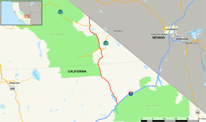
 Map of eastern California with SR 127 highlighted in red | ||||
| Route information | ||||
| Maintained by Caltrans | ||||
| Length | 91.033 mi[1] (146.503 km) | |||
| Major junctions | ||||
| South end | ||||
| North end | ||||
| Location | ||||
| Country | United States | |||
| State | California | |||
| Counties | San Bernardino, Inyo | |||
| Highway system | ||||
| ||||
State Route 127 (SR 127) is a state highway in the U.S. state of California that connects Interstate 15 in Baker to Nevada State Route 373 at the Nevada state line, passing near the eastern boundary of Death Valley National Park. The entire length of the highway closely follows the central portion of the former Tonopah and Tidewater Railroad and loosely follows the Amargosa River.
