Back Кабо-Верде Abkhazian Kaap Verde Afrikaans Kap Verde ALS ካቦ ቨርዴ Amharic Cabo Verde AN Grēnenæs Īega ANG Kabo Vede ANN केप वर्डे ANP الرأس الأخضر Arabic كابو ڤيردي ARY
Republic of Cabo Verde República de Cabo Verde (Portuguese) | |
|---|---|
Motto:
| |
| Anthem: Cântico da Liberdade (Portuguese) (English: "Chant of Freedom") | |
| Capital and largest city | Praia 14°54′59″N 23°30′34″W / 14.91639°N 23.50944°W |
| Official languages | Portuguese[1] |
| Recognised national languages | Cape Verdean Creole[1] |
| Religion (2021) |
|
| Demonym(s) | Cape Verdean or Cabo Verdean[3] |
| Government | Unitary semi-presidential republic[4] |
| José Maria Neves | |
| Ulisses Correia e Silva | |
| Legislature | National Assembly |
| Independence from Portugal | |
• Granted | 5 July 1975 |
| Area | |
• Total | 4,033 km2 (1,557 sq mi) (166th) |
• Water (%) | negligible |
| Population | |
• 2022 census | 593,149[5] (172nd) |
• Density | 147.1/km2 (381.0/sq mi) (89th) |
| GDP (PPP) | 2023 estimate |
• Total | |
• Per capita | |
| GDP (nominal) | 2023 estimate |
• Total | |
• Per capita | |
| Gini (2015) | medium inequality |
| HDI (2022) | medium (131st) |
| Currency | Cape Verdean escudo (CVE) |
| Time zone | UTC–1 (CVT) |
| Date format | dd/mm/yyyy |
| Drives on | Right |
| ISO 3166 code | CV |
| Internet TLD | .cv |
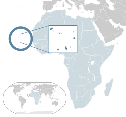
Cape Verde (/ˈvɜːrd(i)/ ⓘ, VURD(-ee)) or Cabo Verde (/ˌkɑːboʊ ˈvɜːrdeɪ/ ⓘ KAH-boh VUR-day, /ˌkæboʊ -/ KAB-oh -, [ˈkabu ˈveɾdɨ]), officially the Republic of Cabo Verde, is an island country and archipelagic state of West Africa in the central Atlantic Ocean, consisting of ten volcanic islands with a combined land area of about 4,033 square kilometres (1,557 sq mi).[9] These islands lie between 600 and 850 kilometres (320 and 460 nautical miles) west of Cap-Vert, the westernmost point of continental Africa. The Cape Verde islands form part of the Macaronesia ecoregion, along with the Azores, the Canary Islands, Madeira and the Savage Isles.
The Cape Verde archipelago was uninhabited by humans until the 15th century, per historical narratives which might not be accurate, when Portuguese explorers colonized the islands, establishing one of the first European settlements in the tropics. Due to its strategic location, Cape Verde became a significant hub in the transatlantic slave trade during the 16th and 17th centuries. The islands experienced economic growth during this period, driven by their role in the slave trade, which also attracted merchants, privateers, and pirates. It declined economically in the 19th century after the suppression of the Atlantic slave trade by the British Empire, and many of its inhabitants emigrated during that period. However, Cape Verde gradually recovered economically by becoming an important commercial center and useful stopover point along major shipping routes. Cape Verde became independent in 1975.
Since the early 1990s, Cape Verde has been a stable representative democracy and has remained one of the most developed and democratic countries in Africa. Lacking natural resources, its developing economy is mostly service-oriented, with a growing focus on tourism and foreign investment. Its population of around 596,000 (as of 2022) is of mostly Sub-Saharan African and minor European heritage, and predominantly Catholic, reflecting the legacy of Portuguese rule. A sizeable Cape Verdean diaspora community exists across the world, especially in the United States and Portugal, considerably outnumbering the inhabitants on the islands. Cape Verde is a member state of the African Union.
Cape Verde's official language is Portuguese.[10] The recognized national language is Cape Verdean Creole, which is spoken by the vast majority of the population. As of the 2021 census the most populated islands were Santiago, where the capital Praia is located (269,370), São Vicente (74,016), Santo Antão (36,632), Fogo (33,519) and Sal (33,347). The largest cities are Praia (137,868), Mindelo (69,013), Espargos (24,500) and Assomada (21,297).[11]
- ^ a b Cite error: The named reference
:0was invoked but never defined (see the help page). - ^ "INE APRESENTA OS RESULTADOS DEFINITIVOS DO V RECENSEAMENTO GERAL DA POPULAÇÃO E HABITAÇÃO (RGPH-2021)". Instituto Nacional de Estatística - INE. 4 April 2022. Retrieved 26 August 2023.
- ^ John Kerry (8 July 2014). "On the Occasion of the Republic of Cabo Verde's National Day". U.S. Department of State. Archived from the original on 21 January 2017. Retrieved 11 July 2014.
On behalf of President Obama and the people of the United States, I send best wishes to Cabo Verdeans as you celebrate 39 years of independence on July 5.
- ^ Amorim Neto, Octávio; Costa Lobo, Marina (2010). "Between Constitutional Diffusion and Local Politics: Semi-Presidentialism in Portuguese-Speaking Countries". SSRN 1644026.
- ^ "Population, total - Cabo Verde". World Bank. Archived from the original on 24 September 2023. Retrieved 17 November 2022.
- ^ a b c d "World Economic Outlook Database, October 2023 Edition. (Cape Verde)". IMF.org. International Monetary Fund. 10 October 2023. Retrieved 26 October 2023.
- ^ "GINI index". World Bank. Archived from the original on 20 December 2013. Retrieved 16 June 2021.
- ^ "Human Development Report 2023/2024" (PDF). United Nations Development Programme. 13 March 2024. Archived (PDF) from the original on 13 March 2024. Retrieved 13 March 2024.
- ^ Tanya Basu (12 December 2013). "Cape Verde Gets New Name: 5 Things to Know About How Maps Change". National Geographic. Archived from the original on 13 December 2013. Retrieved 12 December 2013.
- ^ "Constituição da República de Cabo Verde" (PDF). ICRC databases on international humanitarian law. Article 9. Archived (PDF) from the original on 12 March 2017. Retrieved 11 March 2017.
- ^ "Cape Verde: Islands, Municipalities, Cities & Urban Localities - Population Statistics, Maps, Charts, Weather and Web Information". www.citypopulation.de. Retrieved 7 February 2024.


