Capitol Planning Region | |
|---|---|
| Capitol Region Council of Governments (CRCOG) | |
From top left: Downtown Hartford, University of Connecticut Storrs campus, Downtown New Britain, Blue Back Square, Connecticut State Capitol | |
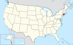
 Location within the U.S. state of Connecticut | |
 Connecticut's location within the U.S. | |
| Coordinates: 41°51′N 72°39′W / 41.85°N 72.65°W | |
| Country | |
| State | |
| Founded | 2013 |
| Largest city | Hartford |
| Other cities | New Britain |
| Government | |
| • Executive Director | Matthew Hart |
| Area | |
• Total | 1,027.3 sq mi (2,661 km2) |
| Population (2020) | |
• Total | 976,248 |
| Time zone | UTC−5 (Eastern) |
| • Summer (DST) | UTC−4 (EDT) |
| Congressional districts | 1st, 2nd, 5th |
| Website | crcog |
The Capitol Planning Region is a planning region and county-equivalent in Connecticut. It is served by the coterminous Capitol Region Council of Governments (CRCOG). In 2022, planning regions were approved to replace Connecticut's counties as county-equivalents for statistical purposes, with full implementation occurring by 2024.[1][2]
- ^ "Governor Lamont Announces U.S. Census Bureau Approves Proposal for Connecticut's Planning Regions To Become County Equivalents". CT.gov. Retrieved March 24, 2023.
- ^ "Change to County-Equivalents in the State of Connecticut". Federal Register. June 6, 2022. Retrieved March 24, 2023.


