Back بحيره كاستل ARZ Касл (кӳлĕ) CV Castle Lake (Siskiyou County, Kalifornien) German Касл (озеро) Russian Castle Gölü (Kaliforniya) Turkish
| Castle Lake | |
|---|---|
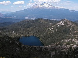
 Castle Lake with Mount Shasta in background | |
| Location | Trinity Mountains, Shasta-Trinity National Forest, Siskiyou County, California |
| Coordinates | 41°13′39″N 122°23′01″W / 41.22750°N 122.38361°W |
| Type | cirque lake |
| Basin countries | United States |
| Surface area | 47 acres (19 ha)[1] |
| Max. depth | 110 ft (34 m)[2] |
| Surface elevation | 5,440 ft (1,660 m)[3] |
| Settlements | Mount Shasta |
| References | [3] |
Castle Lake is a glacial lake (cirque lake or tarn) located in the Trinity Mountains, in Siskiyou County of northern California. It is west of Mount Shasta City and Mount Shasta peak.
The outlet of the lake drains into Castle Lake Creek, and then into Lake Siskiyou reservoir, part of the headwaters of the Sacramento River. Nearly all of the lake's 47 acres (19 ha) are within the Shasta-Trinity National Forest.[1] Trails lead from Castle Lake into the adjacent Castle Crags Wilderness area, and on to Castle Crags State Park, including trails to Little Castle Lake and Heart Lake.[4] Fishing, camping, and hiking are also available at or near the lake.
- ^ a b "Castle Lake". US Department of Agriculture, Forest Service. Retrieved September 30, 2012.
- ^ Cite error: The named reference
CLLRSwas invoked but never defined (see the help page). - ^ a b "Castle Lake". Geographic Names Information System. United States Geological Survey, United States Department of the Interior.
- ^ "Wilderness Area site" (PDF). Archived from the original (PDF) on 2007-04-18. Retrieved 2008-01-14.

