Back মধ্যপ্রদেশ ও বেরার Bengali/Bangla Province Centrali e Berar Italian मध्य प्रांत आणि वऱ्हाड Marathi Центральные провинции и Берар Russian மத்திய மாகாணம் மற்றும் பேரர் Tamil
| Central Provinces and Berar | |||||||||||
|---|---|---|---|---|---|---|---|---|---|---|---|
| Province of British India | |||||||||||
| 1903–1950 | |||||||||||
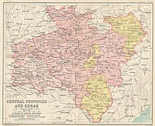
 Central Provinces and Berar in 1909, showing the districts, divisions, and princely states under the authority of the province, as well as the 1905 changes to the eastern boundary | |||||||||||
| Capital | Nagpur | ||||||||||
| Population | |||||||||||
• 1941 | 16,813,584 | ||||||||||
| History | |||||||||||
• Merger of the Central Provinces and Berar Province | 1903 | ||||||||||
• Creation of Madhya Bharat State | 1950 | ||||||||||
| |||||||||||
The Central Provinces and Berar was a province of British India and later the Dominion of India which existed from 1903 to 1950. It was formed by the merger of the Central Provinces with the province of Berar, which was territory leased by the British from the Hyderabad State. Through an agreement signed on 5 November 1902, 6th Nizam Mahbub Ali Khan, Asaf Jah VI leased Berar permanently to the British for an annual payment of 25 lakhs rupees. Lord Curzon decided to merge Berar with the Central Provinces, and this was proclaimed on 17 September 1903.[1]
The Central Provinces was formed in 1861 by the merger of the Saugor and Nerbudda Territories and Nagpur Province. Administration of the Berar region of the Hyderabad princely state was assigned to the Chief Commissioner of the Central Provinces in 1903, and for administrative purposes, Berar was merged with the Central Provinces to form the Central Provinces and Berar on 24 October 1936.[2] After Indian Independence in 1947, a number of princely states were merged into the Central Provinces and Berar, which, when the Constitution of India went into effect in 1950, became the new Indian state of Madhya Bharat, merged with Madhya Pradesh in 1956, also meaning Central Province.
As its name suggests, the province was situated in the center of the Indian peninsula. It comprised large portions of the broad belt of hill and plateau which interposes between the plains of the Ganges and the Deccan Plateau. The Central Provinces and Berar were bounded on the north and northeast by the Central India Agency, including the Bundelkhand and Bagelkhand agencies, and along the northern edge of Saugor District by the United Provinces; on the west by the princely states of Bhopal, Gwalior & Indore and by the Khandesh District of Bombay Presidency; on the south by Hyderabad State, and on the east by Orissa (till 1936, a part of Bihar and Orissa Province) and the Eastern States Agency.
- ^ "Gazetteers of the Bombay Presidency-Buldhana district-History-British Period". Buldhana District Gazetteer website. Archived from the original on 6 October 2008. Retrieved 25 March 2009.
- ^ "Provinces". Retrieved 28 September 2014.

