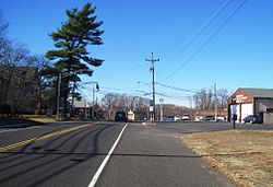
Cheesequake, New Jersey
Chiskhakink (Unami) | |
|---|---|
 Center of Cheesequake along Route 34 | |
| Coordinates: 40°25′29″N 74°17′16″W / 40.42472°N 74.28778°W | |
| Country | |
| State | |
| County | Middlesex |
| Township | Old Bridge |
| Elevation | 102 ft (31 m) |
| Time zone | UTC−05:00 (Eastern (EST)) |
| • Summer (DST) | UTC−04:00 (EDT) |
| Area code(s) | 732 & 848 |
| GNIS feature ID | 875383[1] |
Cheesequake is an unincorporated community located within Old Bridge Township in Middlesex County, in the U.S. state of New Jersey.[2] Cheesequake is located along Route 34, south of Cheesequake State Park.[3][4]
The community's name has been said to be derived from the Lenni Lenape word Cheseh-oh-ke, meaning "upland"[5] or from the word chiskhakink or chickhake, meaning "land that has been cleared."[6][7]
- ^ a b "Cheesequake". Geographic Names Information System. United States Geological Survey, United States Department of the Interior.
- ^ Locality Search, State of New Jersey. Accessed February 7, 2015.
- ^ Middlesex County (PDF) (Map). New Jersey Department of Transportation. Retrieved November 1, 2012.
- ^ "Aerial view of Cheesequake" (Map). Google Maps. Retrieved November 22, 2015.
- ^ "Cheesequake State Park". NY-NJ-CT Botany. Retrieved November 1, 2012.
- ^ Nestor, Sandy. Indian Place Names in America, Volume 1, p. 112. McFarland & Company, 2012. ISBN 9780786493395 Accessed March 26, 2018. "The Lenape Indians inhabited this region for more than 6,000 years. Cheesequake is a Lenape word derived from chickhake, meaning 'land that has been cleared.'"
- ^ "At the land that has been cleared - Cheesequake, NJ". The Lenape Talking Dictionary. Retrieved December 13, 2023.


