Back تشري فالي (إلينوي) Arabic تشرى فالى (بلده فى مقاطعه وينيباجو, الينوى) ARZ چری والی، ایلینوی AZB Cherry Valley (Illinois) Catalan Cherry Valley (lungsod sa Tinipong Bansa, Illinois) CEB Cherry Valley, Illinois Welsh Cherry Valley (Illinois) German Cherry Valley (Illinois) Spanish Cherry Valley (Illinois) Basque چری والی، ایلینوی Persian
Cherry Valley | |
|---|---|
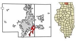
 Location of Cherry Valley in Winnebago and Boone County, Illinois. | |
 Location of Illinois in the United States | |
| Coordinates: 42°14′05″N 88°56′56″W / 42.23472°N 88.94889°W | |
| Country | United States |
| State | Illinois |
| County | Winnebago, Boone |
| Townships | Cherry Valley, Rockford, Belvidere, Flora |
| Government | |
| • Village President | Jim E. Claeyssen[1] |
| Area | |
• Total | 8.66 sq mi (22.42 km2) |
| • Land | 8.40 sq mi (21.77 km2) |
| • Water | 0.25 sq mi (0.65 km2) |
| Elevation | 728 ft (222 m) |
| Population (2020) | |
• Total | 2,905 |
| • Density | 345.63/sq mi (133.45/km2) |
| Time zone | UTC-6 (CST) |
| • Summer (DST) | UTC-5 (CDT) |
| ZIP Code(s) | 61016 |
| Area code | 815 |
| FIPS code | 17-13074 |
| Wikimedia Commons | Cherry Valley, Illinois |
| Website | www |
Cherry Valley is a village of 8.72 square miles (22.6 km2) that lies primarily in Winnebago County. Approximately ten percent of the village is within Boone County. The village is within the Rockford, Illinois Metropolitan Statistical Area, and borders the southeast side of Rockford. It is also within the Kishwaukee River valley. The population is 2,905 at the 2020 census, down from 3,162 as of the 2010 census.
- ^ Bliss, Julie A. (2021). Boone county Illinois year book two thousand twenty one (PDF). Belvidere, Illinois.
{{cite book}}: CS1 maint: location missing publisher (link) - ^ "2020 U.S. Gazetteer Files". United States Census Bureau. Retrieved March 15, 2022.
- ^ "USGS detail on Newtown". Retrieved October 21, 2007.