Back قناة شيكاجو ARZ Chicago Sanitary and Ship Canal CEB Chicago Sanitary and Ship Canal German Chicago Sanitary and Ship Canal French תעלת התברואה והספינות של שיקגו HE Chicago Sanitary and Ship Canal Dutch Chicago Sanitary and Ship Canal NB Chicago Sanitary and Ship Canal Portuguese Чикагский санитарно-судовой канал Russian Chicago Sanitary and Ship Canal SIMPLE
| Chicago Sanitary and Ship Canal | |
|---|---|
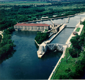
 Lock and dam of the Chicago Sanitary and Ship Canal at Lockport | |
 CSSC highlighted in blue | |
| Specifications | |
| Length | 28 miles (45 km) |
| Locks | 1 |
| Status | Open |
| History | |
| Former names | Chicago Drainage Canal |
| Date completed | January 2, 1900 |
| Date extended | 1907 |
| Geography | |
| Start point | Des Plaines River north of Joliet, Illinois (41°33′19″N 88°04′40″W / 41.5552°N 88.0778°W) |
| End point | South Branch Chicago River in Chicago, Illinois (41°50′30″N 87°40′33″W / 41.8416°N 87.6757°W) |
The Chicago Sanitary and Ship Canal, historically known as the Chicago Drainage Canal, is a 28-mile-long (45 km) canal system that connects the Chicago River to the Des Plaines River. It reverses the direction of the Main Stem and the South Branch of the Chicago River, which now flows out of Lake Michigan rather than into it. The related Calumet-Saganashkee Channel does the same for the Calumet River a short distance to the south, joining the Chicago canal about halfway along its route to the Des Plaines. The two provide the only navigation for ships between the Great Lakes Waterway and the Mississippi River system.
The canal was in part built as a sewage treatment scheme. Prior to its opening in 1900, sewage from the city of Chicago was dumped into the Chicago River and flowed into Lake Michigan. The city's drinking water supply was (and remains) located offshore, and there were fears that the sewage could reach the intake and cause serious disease outbreaks. Since the sewer systems were already flowing into the river, the decision was made to reverse the flow of the river, thereby sending all the sewage inland where it could be diluted before emptying it into the Des Plaines.
Another goal of the construction was to replace the shallow and narrow Illinois and Michigan Canal (I&M), which had originally connected Lake Michigan with the Mississippi starting in 1848. As part of the construction of the new canal, the entire route was built to allow much larger ships to navigate it. It is 202 feet (62 m) wide and 24 feet (7.3 m) deep, over three times the size of the I&M. The I&M became a secondary route with the new canal's opening and was shut down entirely with the creation of the Illinois Waterway network in 1933.
The building of the Chicago canal served as intensive and practical training for engineers who later built the Panama Canal. The canal is operated by the Metropolitan Water Reclamation District of Greater Chicago. In 1999, the system was named a Civil Engineering Monument of the Millennium by the American Society of Civil Engineers (ASCE).[1] The Canal was listed on the National Register of Historic Places on December 20, 2011.[2]
- ^ "Chicago Wastewater System". American Society of Civil Engineers. Archived from the original on 15 January 2012. Retrieved 20 June 2018.
- ^ "Announcement". List for January 13, 2012. National Park Service. Archived from the original on 20 June 2012. Retrieved 26 February 2012.