Back Christiana Afrikaans Christiana (kapital sa munisipyo) CEB Christiana (Südafrika) German Christiana (Nàm-fî) HAK Christiana (Sudafrica) Italian Christiana (Zuid-Afrika) Dutch Christiana NSO Christiana (Południowa Afryka) Polish Christiana Romanian Христиана Russian
Christiana | |
|---|---|
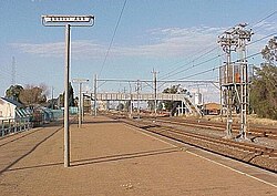
 Christiana railway station | |
| Coordinates: 27°55′12″S 25°9′36″E / 27.92000°S 25.16000°E | |
| Country | South Africa |
| Province | North West |
| District | Dr Ruth Segomotsi Mompati |
| Municipality | Lekwa-Teemane |
| Established | 1870[1] |
| Area | |
• Total | 50.20 km2 (19.38 sq mi) |
| Population (2011)[2] | |
• Total | 3,571 |
| • Density | 71/km2 (180/sq mi) |
| Racial makeup (2011) | |
| • Black African | 16.6% |
| • Coloured | 3.3% |
| • Indian/Asian | 1.1% |
| • White | 77.6% |
| • Other | 1.5% |
| First languages (2011) | |
| • Afrikaans | 84.9% |
| • Tswana | 7.2% |
| • English | 4.4% |
| • Sotho | 1.2% |
| • Other | 2.4% |
| Time zone | UTC+2 (SAST) |
| Postal code (street) | 2680 |
| PO box | 2680 |
| Area code | 053 |
Christiana is an agricultural town of about 3,000 inhabitants on the banks of the Vaal River in North West province, South Africa. The town is located on the N12 national route between Bloemhof and Warrenton, on the way to Kimberley (Northern Cape). It is the administrative centre and seat of Lekwa-Teemane Local Municipality.[3]
- ^ Robson, Linda Gillian (2011). "Annexure A" (PDF). The Royal Engineers and settlement planning in the Cape Colony 1806–1872: Approach, methodology and impact (PhD thesis). University of Pretoria. pp. xlv–lii. hdl:2263/26503.
- ^ a b c d "Main Place Christiana". Census 2011.
- ^ Municipal Demarcation Board : Municipal Profiles 2003 : Contacts Archived 2008-10-07 at the Wayback Machine Retrieved 15 April 2010

