Back চুয়াডাঙ্গা জেলা Bengali/Bangla চুয়াডাঙ্গা জিলা BPY Chuadanga (Distrikt) German Chuadanga (zila) Spanish ناحیه چوادنگه Persian Chuadanga (district) French चौडांगा जिला Hindi Distrik Chuadanga ID Distretto di Chuadanga Italian チュアダンガ県 Japanese
Chuadanga District
চুয়াডাঙ্গা জেলা | |
|---|---|
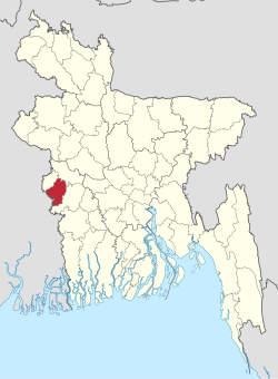
 Location of Chuadanga District in Bangladesh | |
 Expandable map of Chuadanga District | |
| Coordinates: 23°36′N 88°42′E / 23.60°N 88.70°E | |
| Country | |
| Division | Khulna |
| Headquarters | Chuadanga |
| Government | |
| • Deputy Commissioner | Kissinger Chakma |
| Area | |
• Total | 1,174.10 km2 (453.32 sq mi) |
| Population | |
• Total | 1,234,054 |
| • Density | 1,100/km2 (2,700/sq mi) |
| Time zone | UTC+06:00 (BST) |
| Postal code | 7200 |
| Area code | 0761 |
| ISO 3166 code | BD-12 |
| HDI (2019) | 0.644[2] medium · 5th of 20 |
| Website | www |
Chuadanga District (Bengali: চুয়াডাঙ্গা জেলা) is a district of the western Khulna Division of Bangladesh. It is bordered by the Indian state of West Bengal to the west, Meherpur District to the northwest, Jessore District to the south, Jhenaidah District to the east, and Kushtia District to the north. Before partition Chuadanga was one of the five subdivisions of Nadia district.[3]
- ^ Cite error: The named reference
2022censuswas invoked but never defined (see the help page). - ^ "Sub-national HDI - Area Database - Global Data Lab". hdi.globaldatalab.org. Retrieved 18 March 2020.
- ^ "Nadia keeps a date with history". The Times of India. 19 August 2011. Retrieved 23 February 2022.


