Back مقاطعة سيمارون (أوكلاهوما) Arabic Cimarron County, Oklahoma BAR Симърон (окръг, Оклахома) Bulgarian সিমারোন কাউন্টি, ওকলাহোমা BPY Comtat de Cimarron Catalan Cimarron Gông (Oklahoma) CDO Cimarron County CEB Cimarron County, Oklahoma Welsh Cimarron County German Condado de Cimarrón Spanish
Cimarron County | |
|---|---|
 Cimarron County Courthouse in Boise City (2009) | |
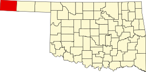
 Location within the U.S. state of Oklahoma | |
 Oklahoma's location within the U.S. | |
| Coordinates: 36°44′N 102°31′W / 36.74°N 102.52°W | |
| Country | |
| State | |
| Founded | 1907 |
| Seat | Boise City |
| Largest city | Boise City |
| Area | |
• Total | 1,841 sq mi (4,770 km2) |
| • Land | 1,835 sq mi (4,750 km2) |
| • Water | 6.1 sq mi (16 km2) 0.3% |
| Population (2020) | |
• Total | 2,296 |
| • Density | 1.2/sq mi (0.5/km2) |
| Time zones | |
| entire county (legally) | UTC−6 (Central) |
| • Summer (DST) | UTC−5 (CDT) |
| Kenton (unofficially) | UTC−7 (Mountain) |
| • Summer (DST) | UTC−6 (MDT) |
Cimarron County is the westernmost county in the U.S. state of Oklahoma. Its county seat is Boise City.[1] As of the 2020 census, its population was 2,296,[2] making it the least-populous county in Oklahoma; and indeed, throughout most of its history, it has had both the smallest population and the lowest population density of any county in Oklahoma. Located in the Oklahoma Panhandle, Cimarron County contains the only community in the state (Kenton) that observes the Mountain Time Zone. Black Mesa, the highest point in the state, is in the northwest corner of the county. The Cimarron County community of Regnier has the distinction of being the driest spot in Oklahoma ranked by lowest annual average precipitation, at just 15.62 inches; at the same time, Boise City is the snowiest location in Oklahoma ranked by highest annual average snowfall, at 31.6 inches.[3]
- ^ "Find a County". National Association of Counties. Archived from the original on May 31, 2011. Retrieved June 7, 2011.
- ^ "State & County QuickFacts". United States Census Bureau. Archived from the original on June 6, 2011. Retrieved November 8, 2013.
- ^ "Oklahoma Annual Rainfall and Climate Data". Coolweather.net. Retrieved November 29, 2020.