Back سيتي كنتربري Arabic شهر کنتربری AZB City of Canterbury CEB Dinas Caergaint Welsh City of Canterbury German Ciudad de Canterbury Spanish شهر کنتربری Persian Cité de Canterbury French City of Canterbury FRR Città di Canterbury Italian
City of Canterbury | |
|---|---|
| Canterbury | |
 Aerial view of Canterbury Cathedral and the surrounding area | |
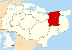
 Canterbury shown within Kent | |
| Sovereign state | United Kingdom |
| Country | England |
| Region | South East England |
| Non-metropolitan county | Kent |
| Status | Non-metropolitan district, Borough, City |
| Admin HQ | Canterbury |
| Incorporated | 1 April 1974 |
| Government | |
| • Type | Non-metropolitan district council |
| • Body | Canterbury City Council |
| • MPs | Rosie Duffield Roger Gale |
| Area | |
• Total | 119.24 sq mi (308.84 km2) |
| • Rank | 117th (of 296) |
| Population (2022) | |
• Total | 157,550 |
| • Rank | 132nd (of 296) |
| • Density | 1,300/sq mi (510/km2) |
| Ethnicity (2021) | |
| • Ethnic groups | |
| Religion (2021) | |
| • Religion | List
|
| Time zone | UTC0 (GMT) |
| • Summer (DST) | UTC+1 (BST) |
| ONS code | 29UC (ONS) E07000106 (GSS) |
| OS grid reference | TR145575 |
 | |
| Click the map for an interactive fullscreen view | |
Canterbury (/ˈkæntərbəri/),[2][3] also known as the City of Canterbury, is a local government district with city status in Kent, England. It is named after its largest settlement, Canterbury, where the council is based. The district also includes the towns of Fordwich, Herne Bay and Whitstable, along with numerous villages and surrounding rural areas. Parts of the district lie within the designated Area of Outstanding Natural Beauty of the Kent Downs.
The neighbouring districts (clockwise from east) are Thanet, Dover, Folkestone and Hythe, Ashford and Swale, all of which are also in Kent. To the north the district has a coast onto the North Sea.
- ^ a b UK Census (2021). "2021 Census Area Profile – Canterbury Local Authority (E07000106)". Nomis. Office for National Statistics. Retrieved 5 January 2024.
- ^ "Local Authority Districts, Counties and Unitary Authorities (April 2021) Map in United Kingdom". Office for National Statistics: Open Geography Portal. Retrieved 1 August 2023.
- ^ "Canterbury". Collins Dictionary. n.d. Archived from the original on 23 September 2015. Retrieved 24 September 2014.