Back Mandurah (rehiyon) CEB Mandurah City German Cité de Mandurah French Città di Mandurah Italian City of Mandurah Dutch Mandurah City Swedish
| City of Mandurah Western Australia | |||||||||||||||
|---|---|---|---|---|---|---|---|---|---|---|---|---|---|---|---|
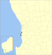
 Location in Western Australia | |||||||||||||||
 | |||||||||||||||
| Population | 90,306 (LGA 2021)[1] | ||||||||||||||
| Established | 1950 | ||||||||||||||
| Area | 174 km2 (67.2 sq mi) | ||||||||||||||
| Mayor | Rhys Williams | ||||||||||||||
| Council seat | Mandurah | ||||||||||||||
| Region | Peel region, Outer southern Perth | ||||||||||||||
| State electorate(s) | Mandurah, Dawesville | ||||||||||||||
| Federal division(s) | Canning | ||||||||||||||
| Website | City of Mandurah | ||||||||||||||
| |||||||||||||||
The City of Mandurah is a local government area of Western Australia, covering both Mandurah proper and an additional area reaching down as far south as Lake Clifton. The city has a total area of approximately 174 square kilometres (67 sq mi).
The city is located in the Peel region, just beyond the southern boundary of metropolitan Perth, and lies about 75 kilometres (47 mi) south of the Perth central business district. It is bordered by the City of Rockingham to the north, the Shire of Murray to the east (the border being for the most part the Harvey Estuary and Serpentine River), and Shire of Waroona to the south.
- ^ Australian Bureau of Statistics (28 June 2022). "Mandurah (Local Government Area)". Australian Census 2021 QuickStats. Retrieved 28 June 2022.