Back Maribyrnong (rehiyon) CEB Maribyrnong City German Ville de Maribyrnong French Kota Maribyrnong ID Città di Maribyrnong Italian Maribyrnong City Dutch City of Maribyrnong Polish City of Maribyrnong Swedish Thành phố Maribyrnong Vietnamese
| City of Maribyrnong Victoria | |||||||||||||||
|---|---|---|---|---|---|---|---|---|---|---|---|---|---|---|---|
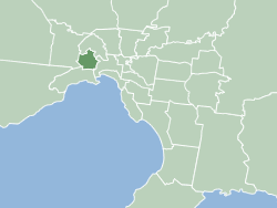
 Map of Melbourne showing location of City of Maribyrnong. | |||||||||||||||
| Population | 91,387 (2018)[1] | ||||||||||||||
| • Density | 2,929/km2 (7,586/sq mi) | ||||||||||||||
| Established | 1994 | ||||||||||||||
| Area | 31.2 km2 (12.0 sq mi)[1] | ||||||||||||||
| Mayor | Pradeep Tiwari | ||||||||||||||
| Council seat | Footscray | ||||||||||||||
| Region | Greater Melbourne | ||||||||||||||
| State electorate(s) | |||||||||||||||
| Federal division(s) | |||||||||||||||
 | |||||||||||||||
| Website | City of Maribyrnong | ||||||||||||||
| |||||||||||||||
The City of Maribyrnong /ˈmærəbənɒŋ/ is a local government area within the metropolitan area of Melbourne, Australia. It comprises the inner western suburbs between 5 and 10 kilometres from Melbourne city centre. It was formed in 1994 from the merger of the City of Footscray and parts of the City of Sunshine. In June 2018, Maribyrnong had a population of 91,387.[1]
According to Local Government Victoria, Maribyrnong has the second most ethnically diverse population in Victoria, with 40% of residents born outside Australia.
Many of Maribyrnong's former industrial sites have been replaced by residential developments. New residents are generally more educated and higher income. Maribyrnong attracted new cultural groups. Its name comes from the nearby Maribyrnong River.
- ^ a b c "3218.0 – Regional Population Growth, Australia, 2017-18: Population Estimates by Local Government Area (ASGS 2018), 2017 to 2018". Australian Bureau of Statistics. 27 March 2019. Retrieved 25 October 2019. Estimated resident population, 30 June 2018.