Back تشيفيتيلا ميسر ريموندو Arabic چیویتلا مسر رایموندو AZB Civitella Messer Raimondo BCL Чивитела Месер Раймондо Bulgarian Civitella Messer Raimondo Breton Чивителла-Мессер-Раймондо CE Civitella Messer Raimondo (munisipyo) CEB Civitella Messer Raimondo German Civitella Messer Raimondo Esperanto Civitella Messer Raimondo Spanish
This article needs additional citations for verification. (March 2008) |
Civitella Messer Raimondo | |
|---|---|
| Comune di Civitella Messer Raimondo | |
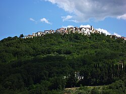
 Panoramic view of Civitella Messer Raimondo | |
| Coordinates: 42°5′N 14°13′E / 42.083°N 14.217°E | |
| Country | Italy |
| Region | Abruzzo |
| Province | Chieti (CH) |
| Frazioni | Calazzotto, Colle San Leonardo, La Fonte, Gallo, Vicenne, La Selva, Forconi, Laruccia, Piano Risorgimento |
| Area | |
• Total | 12 km2 (5 sq mi) |
| Elevation | 613 m (2,011 ft) |
| Population (2004)[2] | |
• Total | 962 |
| • Density | 80/km2 (210/sq mi) |
| Demonym | Civitellesi |
| Time zone | UTC+1 (CET) |
| • Summer (DST) | UTC+2 (CEST) |
| Postal code | 66010 |
| Dialing code | 0872 |
| Patron saint | San Erasmo |
| Saint day | June 2 |
| Website | Official website |
Civitella Messer Raimondo (Abruzzese: Ciuvetàlle) is a town in the province of Chieti in the Abruzzo region of Italy, with a population of 890. It is part of the mountain community of Aventino-Medio Sangro. Until 1863, it was known only as Civitella.
- ^ "Superficie di Comuni Province e Regioni italiane al 9 ottobre 2011". Italian National Institute of Statistics. Retrieved 16 March 2019.
- ^ "Popolazione Residente al 1° Gennaio 2018". Italian National Institute of Statistics. Retrieved 16 March 2019.


