Back كلاي (نيويورك) Arabic كلاى ARZ Клей (Нью-Йорк) CE Clay (New York) German Clay (Nueva York) Spanish Clay (New York) Basque Clay (New York) French Clay, New York HT Clay (New York) Hungarian Clay (New York) Italian
Clay, New York | |
|---|---|
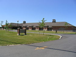
 Clay town hall | |
 Location in Onondaga County and the state of New York. | |
| Coordinates: 43°9′2″N 76°11′39″W / 43.15056°N 76.19417°W | |
| Country | United States |
| State | New York |
| County | Onondaga |
| Government | |
| • Type | Town Council |
| • Town Supervisor | Damian M. Ulatowski (R) |
| • Town Council | Members' List |
| Area | |
• Total | 48.86 sq mi (126.54 km2) |
| • Land | 47.96 sq mi (124.21 km2) |
| • Water | 0.90 sq mi (2.33 km2) |
| Elevation | 377 ft (115 m) |
| Population (2020) | |
• Total | 60,527 |
| • Density | 1,200/sq mi (480/km2) |
| Time zone | UTC-5 (Eastern (EST)) |
| • Summer (DST) | UTC-4 (EDT) |
| ZIP code | 13041, 13090, 13088 |
| Area code | 315 |
| FIPS code | 36-16067 |
| GNIS feature ID | 0978835 |
| Website | Town website |
Clay is a town in Onondaga County, New York, United States. As of the 2020 Census, the population was 60,527, making it Syracuse's most populous suburb. The town was named after American attorney and statesman Henry Clay.
Clay is north of Syracuse. It is the largest town in the county, contains part of the village of North Syracuse, and is a suburb of Syracuse. It contains the major retail strip of Syracuse's northern suburbs, along New York State Route 31 (NY-31), including the currently defunct Great Northern Mall.
- ^ "2016 U.S. Gazetteer Files". United States Census Bureau. Retrieved July 5, 2017.