Back کلای کراس AZB Clay Cross CEB Clay Cross Welsh Clay Cross Spanish Clay Cross Basque کلای کراس Persian Clay Cross French Clay Cross Irish Clay Cross Italian Clay Cross Dutch
| Clay Cross | |
|---|---|
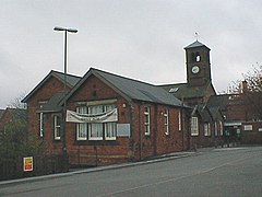
 Clocktower and adult education centre | |
 Clay Cross parish highlighted within Derbyshire | |
| Population | 9,222 (civil parish, 2011)[1] |
| OS grid reference | SK392631 |
| Civil parish |
|
| District | |
| Shire county | |
| Region | |
| Country | England |
| Sovereign state | United Kingdom |
| Post town | CHESTERFIELD |
| Postcode district | S45 |
| Dialling code | 01246 |
| Police | Derbyshire |
| Fire | Derbyshire |
| Ambulance | East Midlands |
| UK Parliament | |
Clay Cross is a town and a civil parish in the North East Derbyshire district of Derbyshire, England. It is a former industrial and mining town, about 5 miles (8.0 km) south of Chesterfield.[3] It is directly on the A61. Surrounding settlements include North Wingfield, Tupton, Pilsley and Ashover.
- ^ "Neighbourhood Statistics". Office for National Statistics. Retrieved 3 January 2015.
- ^ "Clay Cross Parish Council". claycross.gov.uk.
- ^ Chisholm, Hugh, ed. (1911). . Encyclopædia Britannica. Vol. 6 (11th ed.). Cambridge University Press. p. 474.