| Coast Fork Willamette River | |
|---|---|
 The Coast Fork Willamette River | |
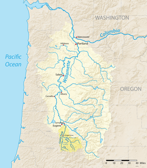
 Map of the Willamette River basin with the Coast Fork highlighted | |
| Etymology | Willamette is from a similar Clackamas Indian village name[2] |
| Location | |
| Country | United States |
| State | Oregon |
| County | Lane |
| Physical characteristics | |
| Source | Confluence of Big River and Garoutte Creek |
| • location | Calapooya Mountains, Oregon |
| • coordinates | 43°35′44″N 123°4′4″W / 43.59556°N 123.06778°W[1] |
| • elevation | 990 ft (300 m)[3] |
| Mouth | Willamette River |
• location | near Eugene and Springfield, Oregon |
• coordinates | 44°1′23″N 123°1′25″W / 44.02306°N 123.02361°W[1] |
• elevation | 436 ft (133 m)[1] |
| Length | 40 mi (64 km)[4] |
| Basin size | 666 sq mi (1,720 km2)[5] |
| Discharge | |
| • location | Goshen, 6.4 miles (10.3 km) from the mouth[6] |
| • average | 1,558 cu ft/s (44.1 m3/s)[7] |
| • minimum | 36 cu ft/s (1.0 m3/s) |
| • maximum | 58,500 cu ft/s (1,660 m3/s) |
| Basin features | |
| Tributaries | |
| • right | Row River |
The Coast Fork Willamette River is one of two forks that unite to form the Willamette River in western Oregon in the United States. It is about 40 miles (64 km) long, draining an area of the mountains at the south end of the Willamette Valley south of Eugene.
- ^ a b c "Coast Fork Willamette River". Geographic Names Information System (GNIS). United States Geological Survey. November 28, 1980. Retrieved August 4, 2010.
- ^ Bright, William (2004). Native American Placenames of the United States. Norman, Oklahoma: University of Oklahoma Press. p. 567. ISBN 978-0-8061-3598-4.
- ^ Source elevation derived from Google Earth search using GNIS source coordinates.
- ^ United States Geological Survey (USGS). "United States Geological Survey Topographic Map: Harness Mountain, Oregon, Quadrant". TopoQuest. Retrieved August 3, 2010. The map includes river-mile markers from mouth to source.
- ^ "Coast Fork Willamette". Willamette Riverkeeper. Archived from the original on August 7, 2010. Retrieved August 4, 2010.
- ^ "Water-data report 2009: 14157500 Coast Fork Willamette River near Goshen, OR" (pdf). United States Geological Survey. Retrieved April 22, 2011.
- ^ "Water-data report 2009: 14157500 Coast Fork Willamette River near Goshen, OR" (pdf). United States Geological Survey. Retrieved April 22, 2011.

