Back Comorosiega ANG جزر كومورو Arabic Archipiélagu de les Comores AST Comoro Islands (kapuloan sa Komoros) CEB Komorské ostrovy Czech Archipel der Komoren German Komora insularo Esperanto Archipiélago de las Comoras Spanish جزایر قمر Persian Komorien saaristo Finnish
 | |
 | |
| Geography | |
|---|---|
| Location | Indian Ocean |
| Coordinates | 12°08′24″S 44°15′00″E / 12.14000°S 44.25000°E |
| Total islands | 4 |
| Major islands | Grande Comore (Ngazidja), Mohéli (Mwali), Anjouan (Nzwani), Mayotte (Maore) |
| Area | 2,034 km2 (785 sq mi) |
| Highest elevation | 2,361 m (7746 ft) |
| Highest point | Karthala |
| Administration | |
Comoros | |
| Autonomous islands | Grande Comore (Ngazidja) Mohéli (Mwali) Anjouan (Nzwani) |
| Largest settlement | Moroni (capital) (pop. 60,200) |
| President | Azali Assoumani |
France | |
| Overseas department | Mayotte |
| Largest settlement | Mamoudzou (pop. 53,022) |
| Demographics | |
| Population | 1,008,246 (2016 est.) |
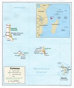
The Comoro Islands are a group of volcanic islands in the Mozambique Channel, an arm of the Indian Ocean lying between Madagascar and the African mainland. Three of the islands form the Union of the Comoros, a sovereign nation, while Mayotte belongs to France.