43°39′25″N 70°15′36″W / 43.656872°N 70.259981°W
| Country Road (formerly) Back Street (formerly) Queen Street (formerly) | |
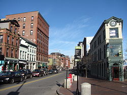
 Congress Street, looking northeast from Congress Square | |
 | |
| Part of | |
|---|---|
| Length | 5.77 mi (9.29 km) |
| Location | Portland, Maine, U.S. |
| Southwest end | County Road |
| Northeast end | Eastern Promenade |


Congress Street is the main street in Portland, Maine. Around 5.77 miles (9.29 km) long, it stretches from County Road, Portland's southwestern border with Westbrook, through a number of neighborhoods, before ending overlooking the Eastern Promenade on Munjoy Hill. In March 2009, the Portland City Council designated much of the inner portion of Congress Street a historic district.[1][2] The western section of the street includes the city's Arts District.
The street was formerly known as both Country Road and Back Street.[3] West of downtown Portland, the street is known colloquially as Outer Congress Street.[4]
Portland City Hall stands at 389 Congress Street, at the head of Exchange Street.
- ^ Proposed Congress Street Historic District Archived 2011-07-21 at the Wayback Machine City of Portland, Maine
- ^ Recommendation of the Historic Preservation Board Archived 2011-07-21 at the Wayback Machine February 2009
- ^ The Origins of the Street Names of the City of Portland, Maine as of 1995 – Norm and Althea Green, Portland Public Library (1995)
- ^ "Portland Social Security office moving". Press Herald. 2023-04-25. Retrieved 2024-03-29.
