Back الولايات الأمريكية المتجاورة Arabic Kontinental ABŞ Azerbaijani Кантынентальныя штаты Byelorussian Континентални щати Bulgarian Estats Units contigus Catalan ویلایەتە یەکگرتووە پێکلکاوەکان CKB Sousedící státy Spojených států amerických Czech Kontinentale USA Danish Contiguous United States German Conus DIQ


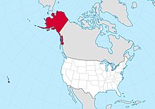
The contiguous United States (officially the conterminous United States) consists of the 48 adjoining U.S. states and the District of Columbia of the United States in central North America.[1][2] The term excludes the only two non-contiguous states, which are Alaska and Hawaii (they are also the last two states to be admitted to the Union), and all other offshore insular areas, such as the U.S. territories of American Samoa, Guam, the Northern Mariana Islands, Puerto Rico, and the U.S. Virgin Islands.[3][4] The colloquial term "Lower 48"[5] is also used, especially in relation to Alaska.
The related but distinct term continental United States includes Alaska, which is also on North America, but separated from the 48 states by British Columbia in Canada, but excludes Hawaii and all the insular areas in the Caribbean and the Pacific.[1][6]
The greatest distance (on a great-circle route) entirely within the contiguous U.S. is 2,802 miles (4,509 km), coast-to-coast between Florida and the State of Washington;[7] the greatest north–south line is 1,650 miles (2,660 km).[8] The contiguous United States occupies an area of 3,119,884.69 square miles (8,080,464.3 km2). Of this area, 2,959,064.44 square miles (7,663,941.7 km2) is actual land, composing 83.65 percent of the country's total land area, and is comparable in size to the area of Australia.[9] Officially, 160,820.25 square miles (416,522.5 km2) of the contiguous United States is water area, composing 62.66 percent of the nation's total water area.
The contiguous United States, if it were a country, would be fifth on the list of countries and dependencies by area, behind Russia, Canada, China, and Brazil. However, the total area of the United States, including Alaska and Hawaii, ranks third or fourth. Brazil is 431,000 square kilometers (166,000 sq mi) larger than the contiguous United States, but smaller than the entire United States including Alaska, Hawaii and overseas territories. The 2020 U.S. census population of the area was 328,571,074, comprising 99.13 percent of the nation's total population, and a density of 111.04 inhabitants/sq mi (42.872/km2), compared to 93.844/sq mi (36.233/km2) for the nation as a whole.[10]
- ^ a b "What constitutes the United States, what are the official definitions?". U.S. Geological Survey. Archived from the original on November 16, 2017. Retrieved January 30, 2019.
- ^ "United Airlines website". Archived from the original on April 2, 2012. Retrieved April 4, 2012.
Contiguous United States: The 48 adjoining states and the District of Columbia.
- ^ Random House (1991). Random House Webster's College Dictionary. New York: Random House. ISBN 0-679-40110-5.
- ^ These maps show the contiguous 48 states and D.C., but not Alaska and Hawaii.
- "Military Bases in the Contiguous United States". National Park Service, U.S. Department of the Interior. Archived from the original on December 26, 2018. Retrieved November 28, 2012.
- "Soil Moisture Regimes of the Contiguous United States". U.S. Department of Agriculture. Archived from the original on May 13, 2013. Retrieved November 28, 2012.
- ^ "National Geographic Style Manual: Alaska". Archived from the original on October 28, 2011. Retrieved December 6, 2013.
The continental United States includes Alaska. [...] In Alaska context, lower forty-eight or lower 48 may be used. Do not hyphenate lower 48 as an adjective. The term outside may be put in quotes on first reference if ambiguous. To distinguish the 48 states from the 49 or 50, use contiguous or conterminous.
- ^ Hyslop, Stephen G. (April 5, 1996). Political Geography of the United States. Guilford Press. p. 90.
- ^ Pickover, Cliff. "The Longest Line in America!". University of Wisconsin. Archived from the original on June 9, 2014. Retrieved October 15, 2013.
- ^ "HowStuffWorks "Geography of the United States - Geography"". Geography.howstuffworks.com. March 30, 2008. Archived from the original on January 19, 2016. Retrieved October 29, 2013.
- ^ "Field Listing: Area". The World Factbook. cia.gov. Archived from the original on July 7, 2020. Retrieved June 13, 2019.
- ^ "Resident Population Data - 2010 Census". United States Census Bureau. Archived from the original on October 28, 2011. Retrieved January 30, 2011.