Back Кантрольны пункт Byelorussian Posten (Orientierungslauf) German Kontrollpunkt Estonian Rasti Finnish Контрольный пункт Russian Karttecken inom orientering Swedish Контроль пункт (ориентлашу) Tatar Контрольний пункт Ukrainian


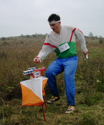
A control point (CP, also control and checkpoint) is a marked waypoint used in orienteering and related sports such as rogaining and adventure racing. It is located in the competition area; marked both on an orienteering map and in the terrain, and described on a control description sheet. The control point must be identifiable on the map and on the ground. A control point has three components: a high visibility item, known as a flag or kite; an identifier, known as a control code; and a recording mechanism for contestants to record proof that they visited the control point. The control point is usually temporary, except on a permanent orienteering course.
For events held under International Orienteering Federation (IOF) rules the kite has a triangular form with each face being about 30 cm x 30 cm and coloured white and orange. Most national governing bodies, and related sports use the same design. The earlier specification used white and red.
The location of control points is kept secret from the competitors until the start of the competition when they receive the map.[1] The map may be pre-printed with the control points, or the competitor may be required to copy control points onto the map from a master map.[2] Control points are selected and prepared anew for each competition. Permanent courses, with their permanent control points, are used primarily for training and recreation, but rarely for competition.
- ^ "About Orienteering". The Canadian Orienteering Federation. Archived from the original on 2008-10-02. Retrieved 2008-08-11.
- ^ "Orienteering". sroc.org. Retrieved 2008-08-11.