Back Coolamon (rehiyon) CEB Coolamon Shire German Comté de Coolamon French Contea di Coolamon Italian Coolamon Shire Council Dutch Coolamon Shire Swedish
| Coolamon Shire New South Wales | |||||||||||||||
|---|---|---|---|---|---|---|---|---|---|---|---|---|---|---|---|
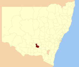
 Location in New South Wales | |||||||||||||||
| Coordinates | 34°50′S 147°12′E / 34.833°S 147.200°E | ||||||||||||||
| Population |
| ||||||||||||||
| • Density | 1.7735/km2 (4.5934/sq mi) | ||||||||||||||
| Established | 6 March 1906 | ||||||||||||||
| Area | 2,433 km2 (939.4 sq mi) | ||||||||||||||
| Mayor | David McCann (Independent) | ||||||||||||||
| Council seat | Coolamon[3] | ||||||||||||||
| Region | Riverina | ||||||||||||||
| County | Bourke | ||||||||||||||
| State electorate(s) | Cootamundra | ||||||||||||||
| Federal division(s) | Riverina | ||||||||||||||
 | |||||||||||||||
| Website | Coolamon Shire | ||||||||||||||
| |||||||||||||||
Coolamon Shire is a local government area in the Riverina region of south-western New South Wales, Australia. The Shire comprises 2,433 square kilometres (939 sq mi) and is located adjacent to the Newell Highway and the Burley Griffin Way. The Shire includes the towns of Coolamon, Ganmain, and Ardlethan, and the villages of Matong, Marrar, and Beckom.
The mayor of the Coolamon Shire Council is Cr. David McCann, an independent politician.[4]
- ^ Australian Bureau of Statistics (27 June 2017). "Coolamon (A)". 2016 Census QuickStats. Retrieved 8 December 2017.
- ^ "3218.0 – Regional Population Growth, Australia, 2017–18". Australian Bureau of Statistics. 27 March 2019. Retrieved 27 March 2019. Estimated resident population (ERP) at 30 June 2018.
- ^ "Coolamon Shire Council". Department of Local Government. Retrieved 8 November 2006.
- ^ Cite error: The named reference
:0was invoked but never defined (see the help page).