Back Корентина Bulgarian কোর্রেন্টিনা BPY Коррентина CE Correntina (munisipyo) CEB Correntina Esperanto Correntina Spanish Correntina Basque Correntina French Կոռենտինա Armenian Correntina Italian
This article needs additional citations for verification. (March 2009) |
Correntina | |
|---|---|
 Bridge crossing the Das Éguas River with Church of Our Lady of Gloria in the background | |
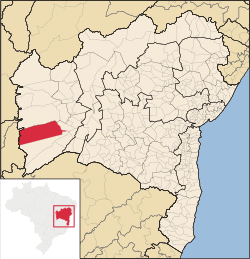
 Location of Correntina in Bahia | |
| Coordinates: 13°20′35″S 44°38′10″W / 13.34306°S 44.63611°W | |
| Country | |
| Region | Northeast |
| State | |
| Founded | 15 May 1866[2] |
| Government | |
| • Mayor | Walter Mariano Messias de Souza (UNIÃO) (2025-2028)[3][4] |
| • Vice Mayor | Cassimiro Castro e Silva (PRD) (2025-2028)[3][4] |
| Area | |
• Total | 11,504.314 km2 (4,441.840 sq mi) |
| Elevation | 575 m (1,886 ft) |
| Population (2022) | |
• Total | 32,457[1] |
| • Density | 2.82/km2 (7.3/sq mi) |
| Demonym | Correntinense (Brazilian Portuguese)[1] |
| Time zone | UTC-03:00 (Brasília Time) |
| Postal code | 47650-000, 47654-000[5] |
| HDI (2010) | 0.603 – medium[1] |
| Website | correntina.ba.gov.br |
Correntina is a municipality in the state of Bahia in Brazil, 500 km from Brasília and 980 km from Salvador. In 2020, the population was estimated at 32,191.[6]
- ^ a b c "Correntina". Instituto Brasileiro de Geografia e Estatística. Instituto Brasileiro de Geografia e Estatística. Retrieved 3 September 2024.
- ^ "História". Instituto Brasileiro de Geografia e Estatística. Instituto Brasileiro de Geografia e Estatística. Retrieved 3 September 2024.
- ^ a b "Eleições 2024: Mariano Correntina (UNIÃO) | Candidato(a) a prefeito(a) de Correntina-BA". Folha de S.Paulo (in Brazilian Portuguese). Folha de S.Paulo. 30 November 2024. Retrieved 12 January 2025.
- ^ a b "Prefeito de Correntina (BA) toma posse nesta quarta (1º); veja lista de vereadores eleitos". G1 (in Brazilian Portuguese). Globo. 31 December 2024. Retrieved 12 January 2025.
- ^ "Código Postal Correntina/BA - Brasil". Código Postal. Código Postal. Retrieved 4 September 2024.
- ^ IBGE 2020


