Back Craigavon Afrikaans کریقآوون AZB Крейгейвън Bulgarian Craigavon Catalan Craigavon (kapital sa distrito sa Hiniusang Gingharian) CEB Creag Abhann Welsh Craigavon German Craigavon Spanish Craigavon Basque کریگآوون Persian
| Craigavon | |
|---|---|
| Town | |
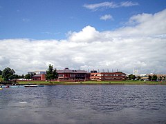
 Craigavon Civic Centre from Craigavon Lakes | |
Location within Northern Ireland | |
| Population | (2021)[1]
|
| Irish grid reference | J042562 |
| • Belfast | 21 miles (34 km)[2] |
| District | |
| County | |
| Country | Northern Ireland |
| Sovereign state | United Kingdom |
| Post town | CRAIGAVON |
| Postcode district | BT62–BT67 |
| Dialling code | 028 |
| Police | Northern Ireland |
| Fire | Northern Ireland |
| Ambulance | Northern Ireland |
| UK Parliament | |
| NI Assembly | |
| Website | www.craigavon.gov.uk |
Craigavon is a town in northern County Armagh, Northern Ireland. Its construction began in 1965 and it was named after the first Prime Minister of Northern Ireland: James Craig, 1st Viscount Craigavon.[3][4] It was intended to be the heart of a new linear city incorporating Lurgan and Portadown, but this plan was mostly abandoned and later described as having been flawed.[5] Among local people today, "Craigavon" refers to the area between the two towns.[6] It is built beside a pair of artificial lakes and is made up of a large residential area (Brownlow), a second smaller one (Mandeville), plus a central area (Highfield) that includes a substantial shopping centre, a courthouse and the district council headquarters. The area around the lakes is a public park and wildlife haven made up of woodland with walking trails. There is also a watersports centre, golf course and ski slope in the area. In most of Craigavon, motor vehicles are completely separated from pedestrians, and roundabouts are used extensively. It hosted the headquarters of the former Craigavon Borough Council.
Craigavon sometimes refers to the much larger Craigavon Urban Area, a name used by the Northern Ireland Statistics and Research Agency, which includes Craigavon, Lurgan, Portadown and Aghacommon.[7]
- ^ Cite error: The named reference
2021 popwas invoked but never defined (see the help page). - ^ "How Far Is It Between". www.freemaptools.com.
- ^ "Place Names NI - Home". Place Names NI. Archived from the original on 14 June 2021. Retrieved 3 October 2020.
- ^ "Craigavon town planning: British Modernism 50 years on". BBC News. 25 October 2014. Retrieved 1 September 2020.
- ^ "Craigavon town planning: British Modernism 50 years on". BBC News. 25 October 2014. Retrieved 12 December 2016.
- ^ Cite error: The named reference
beltelwas invoked but never defined (see the help page). - ^ Map for location Craigavon Urban Area including Aghacommon. Northern Ireland Statistics and Research Agency.
