Back Хърватско приморие Bulgarian Hrvatsko primorje BS Chorvatské Přímoří Czech Kroatisches Küstenland German Littoral croate French Hrvatsko primorje Croatian Horvát tengermellék Hungarian ხორვატული ზღვისპირეთი Georgian Hrvatsko primorje Polish Hrvatsko primorje Serbo-Croatian
Croatian Littoral
Hrvatsko primorje | |
|---|---|
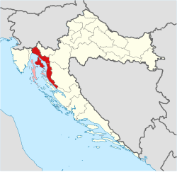
 Croatian Littoral on a map of Croatia Croatian Littoral Sometimes considered part of the Croatian Littoral | |
| Country | |
| Largest city | Rijeka |
| Area b | |
• Total | 2,997 km2 (1,157 sq mi) |
| Population (2021[1])b | |
• Total | 227,951 |
| • Density | 76/km2 (200/sq mi) |
| a Croatian Littoral is not designated as an official region; it is a geographical region only.
b The figure is an approximation based on the territorial span and population of the municipalities bounded by geographical regions of Istria, Mountainous Croatia, and Dalmatia, including the Kvarner Gulf islands. | |
Croatian Littoral (Croatian: Hrvatsko primorje) is a historical name for the region of Croatia comprising mostly the coastal areas between traditional Dalmatia to the south, Mountainous Croatia to the north, Istria and the Kvarner Gulf of the Adriatic Sea to the west. The term "Croatian Littoral" developed in the 18th and 19th centuries, reflecting the complex development of Croatia in historical and geographical terms.
The region saw frequent changes to its ruling powers since classical antiquity, including the Roman Empire, the Ostrogoths, the Lombards, the Byzantine Empire, the Frankish Empire, and the Croats, some of whose major historical heritage originates from the area—most notably the Baška tablet. The region and adjacent territories became a point of contention between major European powers, including the Republic of Venice, the Kingdom of Hungary, and the Habsburg and Ottoman Empires, as well as Austria, the First French Empire, the Kingdom of Italy, and Yugoslavia.
- ^ "Results" (xlsx). Census of Population, Households and Dwellings in 2021. Zagreb: Croatian Bureau of Statistics. 2022. Retrieved 16 January 2022.