Back كمبرلاند (ماريلاند) Arabic كمبرلاند (الجنى, ميريلاند) ARZ کومبرلاند، مریلند AZB Cumberland (Maryland) Catalan Камберленд (Мэриленд) CE Cumberland (kapital sa kondado sa Tinipong Bansa, Maryland) CEB Cumberland, Maryland Welsh Cumberland (Maryland) Danish Cumberland DAG Cumberland (Maryland) German
Cumberland, Maryland | |
|---|---|
 Washington St. and Greene St. in Cumberland | |
| Nicknames: "Queen City" | |
| Motto(s): "Come for a Visit, Stay for Life!" | |
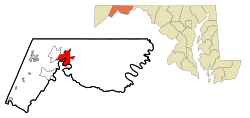
 Location in Allegany County and in Maryland | |
| Coordinates: 39°38′20″N 78°44′30″W / 39.63889°N 78.74167°W | |
| Country | |
| State | |
| County | |
| Founded | 1787 |
| Incorporated | January 23, 1815[1]: 44 |
| Government | |
| • Type | Council-CEO |
| Area | |
• Total | 10.12 sq mi (26.22 km2) |
| • Land | 10.06 sq mi (26.04 km2) |
| • Water | 0.07 sq mi (0.18 km2) |
| Elevation | 640 ft (200 m) |
| Population (2020) | |
• Total | 19,076 |
| • Density | 1,897/sq mi (732/km2) |
| • Demonym | Cumberlander |
| Time zone | UTC−5 (Eastern (EST)) |
| • Summer (DST) | UTC−4 (EDT) |
| ZIP Codes | 21501–21505 |
| Area code(s) | 301, 240 |
| FIPS code | 24-21325 |
| GNIS feature ID | 2390580[3] |
| Website | www |
Cumberland is a city in and the county seat of Allegany County, Maryland, United States. At the 2020 census, the city had a population of 19,075.[4] Located on the Potomac River, Cumberland is a regional business and commercial center for Western Maryland and the Potomac Highlands of West Virginia. It is the primary city of the Cumberland metropolitan area, which had 95,044 residents in 2020.[5]
Historically, Cumberland was known as the "Queen City" as it was once the second largest in the state. Because of its strategic location on what became known as the Cumberland Road through the Appalachians, after the American Revolution it served as a historical outfitting and staging point for westward emigrant trail migrations throughout the first half of the 1800s. In this role, it supported the settlement of the Ohio Country and the lands in that latitude of the Louisiana Purchase. It also became an industrial center, served by major roads, railroads, and the Chesapeake and Ohio Canal, which connected Cumberland to Washington, D.C. and is now a national historical park. Today, Interstate 68 bisects the town.
Industry declined after World War II, leading urban, business, and technological development in the state to be concentrated in eastern coastal cities. Today, the Cumberland metropolitan area is one of the poorest in the United States, ranking 305th out of 318 metropolitan areas in per capita income.[6]
- ^ "Comprehensive Annual Financial Report for the Fiscal Year End June 30, 2021" (Archived July 16, 2022, at the Wayback Machine). City of Cumberland, Maryland. December 17, 2021.
- ^ "2020 U.S. Gazetteer Files". United States Census Bureau. Archived from the original on March 5, 2023. Retrieved April 26, 2022.
- ^ a b U.S. Geological Survey Geographic Names Information System: Cumberland, Maryland
- ^ "QuickFacts: Cumberland city". United States Census Bureau. Archived from the original on January 18, 2024. Retrieved August 16, 2021.
- ^ "2020 Population and Housing State Data". United States Census Bureau, Population Division. August 12, 2021. Archived from the original on August 12, 2021. Retrieved August 14, 2021.
- ^ Dataplace: Cumberland, MD-WV MAS Archived 2007-09-28 at the Wayback Machine


