Back Cumulus congestus Catalan Cumulus congestus Czech Cumulus congestus Spanish ابر کومهای ستبر Persian Cumulus congestus Finnish Cumulus congestus French Awan kumulus kongestus ID Cumulus congestus Italian 웅대적운 Korean Cumulus congestus LMO
| Cumulus congestus | |
|---|---|
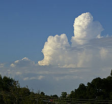
 Cumulus congestus clouds looming over the horizon, as seen from Wagga Wagga, NSW, Australia | |
| Abbreviation | Cu con |
| Symbol | |
| Genus | Cumulus ("heaped") |
| Species | Congestus ("piled up") |
| Variety |
|
| Altitude | Up to 6,000 m (Up to 20,000 ft) |
| Classification | Family D (Vertically developed) |
| Appearance | Low-altitude, vertical, taller than it is wide, fluffy heaps of clouds with cotton-like appearance. |
| Precipitation | Rain, snow, or snow pellets.[1] |
Cumulus congestus or towering cumulus clouds are a species of cumulus that can be based in the low- to middle-height ranges. They achieve considerable vertical development in areas of deep, moist convection. They are an intermediate stage between cumulus mediocris and cumulonimbus, sometimes producing rainshowers, snow, or ice pellets.[2] Precipitation that evaporates before reaching the surface is virga.
- ^ "Cumulus Congestus". Glossary of Meteorology. American Meteorological Society. Retrieved 2021-04-16.
- ^ "Learn About Cumulus Congestus Clouds". whatsthiscloud.com. Retrieved 2021-03-22.