Back كوشينغ (أوكلاهوما) Arabic كوشينج (بايين) ARZ کوشینق، اوکلاهوما AZB Кушынг (Аклахома) Byelorussian Cushing (Oklahoma) Catalan Кушинг (Оклахома) CE Cushing (lungsod sa Tinipong Bansa, Oklahoma) CEB Cushing DAG Cushing (Oklahoma) German Cushing (Oklahoma) Spanish
Cushing, Oklahoma
Koshineki | |
|---|---|
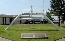
 Pipeline Crossroads of the World monument (2006) | |
| Nickname: "Pipeline Crossroads of the World" | |
 Location within Payne County and Oklahoma | |
| Coordinates: 35°58′47″N 96°45′39″W / 35.97972°N 96.76083°W | |
| Country | United States |
| State | Oklahoma |
| County | Payne |
| Area | |
• Total | 7.60 sq mi (19.69 km2) |
| • Land | 7.59 sq mi (19.67 km2) |
| • Water | 0.01 sq mi (0.02 km2) |
| Elevation | 922 ft (281 m) |
| Population (2020) | |
• Total | 8,327 |
| • Density | 1,096.38/sq mi (423.32/km2) |
| Time zone | UTC-6 (CST) |
| • Summer (DST) | UTC-5 (CDT) |
| ZIP code | 74023 |
| Area code | 539/918 |
| FIPS code | 40-18850[3] |
| GNIS feature ID | 2410279[2] |
| Website | www |
Cushing (Meskwaki: Koshineki,[4] Iowa-Oto: Amína P^óp^oye Chína, meaning: "Soft-seat town"[5]) is a city in Payne County, Oklahoma, United States. The population was 7,826 at the time of the 2010 census, a decline of 6.5% since 8,371 in 2000.[6] Cushing was established after the Land Run of 1891 by William "Billy Rae" Little. It was named for Marshall Cushing, private secretary to U.S. Postmaster General John Wanamaker.
A 1912 oil boom led to the city's development as a refining center,[7] with over 50 refineries operating in Cushing over its history.[8] Today, Cushing is a major trading hub for crude oil and a price settlement point for West Texas Intermediate on the New York Mercantile Exchange[9] and is known as the "Pipeline Crossroads of the World."
- ^ "ArcGIS REST Services Directory". United States Census Bureau. Retrieved September 20, 2022.
- ^ a b U.S. Geological Survey Geographic Names Information System: Cushing, Oklahoma
- ^ "U.S. Census website". United States Census Bureau. Retrieved January 31, 2008.
- ^ Gordon Whittaker, 2005, "A Concise Dictionary of the Sauk Language", The Sac & Fox National Public Library Stroud, Oklahoma. [1]
- ^ (2008) Kansas Historical Society, Ioway-Otoe-Missouria Language Project, English to Ioway-Otoe-Missouria Dictionary, "Dictionary C (English to Baxoje)", "Cushing, Okla.". [2]
- ^ "Cushing, OK Population - Census 2010 and 2000 Interactive Map, Demographics, Statistics, Quick Facts - CensusViewer". censusviewer.com. Archived from the original on June 15, 2013. Retrieved March 27, 2012.
- ^ Encyclopedia of Oklahoma History and Culture."Cushing". By D. Earl Newsome, Accessed June 9, 2010.
- ^ Cite error: The named reference
Refinerywas invoked but never defined (see the help page). - ^ "NYMEX WTI Crude Oil Futures & Options". www.cmegroup.com.