Back جبال الظهرة Arabic Οροσειρά Νταχρά Greek Sierra de Dahra Spanish Dahra (mendilerroa) Basque جبال الظهره، الجزایر Persian Dahra (massif) French Dahra (massiccio) Italian Ciadëina de Dahra LLD 達赫拉山脈 Chinese
| Dahra Range | |
|---|---|
| جبال الظهرة | |
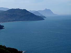
 View of the coastal Dahra Range in Cap Ténès | |
| Highest point | |
| Peak | Mount Zaccar (Miliana) |
| Elevation | 1,550 m (5,090 ft) |
| Coordinates | 36°35′0″N 1°40′0″E / 36.58333°N 1.66667°E[1] |
| Geography | |
| Parent range | Tell Atlas |
The Dahra Range (Arabic: جبال الظهرة) is a mountain range located in northern Algeria. 'Dahra' is an Arabic word meaning 'back'; in toponymy this term indicates a long plateau of lesser altitude.[2]
- ^ Google Earth
- ^ E.B., « Dahra », in Encyclopédie berbère, 14
