Back مقاطعة ديفيس (إنديانا) Arabic Daviess County, Indiana BAR Дейвис (окръг, Индиана) Bulgarian ডাভিয়েস কাউন্টি, ইন্ডিয়ানা BPY Daviess Gông (Indiana) CDO Дейвис (гуо, Индиана) CE Daviess County (kondado sa Tinipong Bansa, Indiana) CEB Daviess County, Indiana Welsh Daviess County (Indiana) German Κομητεία Ντέιβις (Ιντιάνα) Greek
Daviess County | |
|---|---|
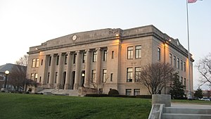
 Daviess County courthouse | |
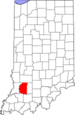
 Location within the U.S. state of Indiana | |
 Indiana's location within the U.S. | |
| Coordinates: 38°42′N 87°05′W / 38.7°N 87.08°W | |
| Country | |
| State | |
| Founded | February 2, 1818 |
| Named for | Joseph Hamilton Daveiss |
| Seat | Washington |
| Largest town | Washington |
| Area | |
• Total | 436.87 sq mi (1,131.5 km2) |
| • Land | 429.49 sq mi (1,112.4 km2) |
| • Water | 7.39 sq mi (19.1 km2) 1.69% |
| Population (2020) | |
• Total | 33,381 |
• Estimate (2022)[1] | 33,418 |
| • Density | 76/sq mi (30/km2) |
| Time zone | UTC−5 (Eastern) |
| • Summer (DST) | UTC−4 (EDT) |
| Congressional district | 8th |
| Website | www |
|
Indiana county number 14
| |
Daviess County /ˈdeɪviːz/ is a county in the U.S. state of Indiana. As of the 2020 United States Census, the population was 33,381.[2] The county seat is Washington.[3] About 15% of the county's population is Amish of Swiss origin, as of 2017.[4]
- ^ "QuickFacts: Daviess County, Indiana". Census.gov. Retrieved July 7, 2023.
- ^ "Daviess County, Indiana". United States Census Bureau. Retrieved May 30, 2023.
- ^ "Find a County". National Association of Counties. Archived from the original on May 31, 2011. Retrieved June 7, 2011.
- ^ Cite error: The named reference
updatewas invoked but never defined (see the help page).