Back देवरिया Bihari দেউরিয়া BPY Deoria (lungsod) CEB Deoria German Deoria Esperanto Deoria Spanish Deoria French देवरिया Hindi Deoria Italian देवरिया Marathi
Deoria | |
|---|---|
City | |
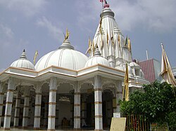
 Shyam Mandir Temple | |
| Coordinates: 26°30′06″N 83°46′46″E / 26.50167°N 83.77936°E | |
| Country | |
| State | |
| District | Deoria |
| Government | |
| • Type | Municipal Council |
| • Body | Deoria Municipal Council |
| • Chairman of Municipality | Alka Singh |
| Elevation | 68 m (223 ft) |
| Population (2011) | |
• Total | 129,479 |
| Language | |
| • Official | Hindi[2] |
| • Additional official | Urdu[2] |
| • Regional | Bhojpuri |
| Time zone | UTC+5:30 (IST) |
| PIN | 274001 |
| Telephone code | 05568 |
| Vehicle registration | UP-52 |
| Website | Official Website |
District Officers | |
|---|---|
 | |
| Government | |
| • D.M. | Divya Mital[3][4] |
| • A.D.M(F/R) | Umesh Kumar Mangala[3] |
| • A.D.M(E) | Rakesh Kumar Patel |
| • S.P. | Shripati Mishra |
| • CDO | Shivsharnappa GN |
Deoria is a city in the state of Uttar Pradesh, India. Deoria is located 45 km east of Gorakhpur and about 317 km from the state capital Lucknow. It shares its eastern border with the Indian state of Bihar. It is one of five tehsils of the Deoria district and serves as the administrative headquarters of that district, and is part of the Gorakhpur division. The city is situated between 26°6' and 26°48' North latitudes and 83°23' and 84°16' East longitudes, with major rivers such as the Ghaghara, Rapti, and Chhoti Gandak flowing through the region. Deoria is well known for its fertile plains, which support the cultivation of crops like sugarcane, wheat, and rice. As per the 2011 Census, the population of Deoria city was 129,479, with a literacy rate of 86.8%.[5] The city is an important agricultural and trade hub in the region and is well connected by road and rail networks to other parts of Uttar Pradesh and Bihar.[6]
- ^ Cite error: The named reference
Census2011Govwas invoked but never defined (see the help page). - ^ a b "52nd Report of the Commissioner for Linguistic Minorities in India" (PDF). nclm.nic.in. Ministry of Minority Affairs. Archived from the original (PDF) on 25 May 2017. Retrieved 1 April 2019.
- ^ a b "Who's Who | District Deoria, Government Of Uttar Pradesh | India". deoria.nic.in. Retrieved 22 March 2022.
- ^ "नवागत जिलाधिकारी ने किया पदभार ग्रहण". Amar Ujala (in Hindi). 4 June 2023. Retrieved 9 August 2023.
- ^ "Deoria District Overview". Deoria Uponline. Retrieved 23 January 2025.
- ^ "Deoria Geography and Economy". Encyclopaedia Britannica. Retrieved 23 January 2025.

