Back Derbyshire Afrikaans Derbyshire AN Dēorabysċīr ANG ديربيشاير Arabic Derbyshire AST Derbyshire BAN Дэрбішыр Byelorussian Дэрбішыр BE-X-OLD Дарбишър Bulgarian ডার্বিশায়ার Bengali/Bangla
Derbyshire | |
|---|---|
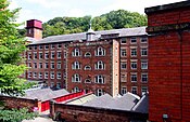
The Peak District near Hathersage; Derby Cathedral; and Masson Mill, opened by Sir Richard Arkwright | |
| Coordinates: 53°11′N 1°37′W / 53.18°N 1.61°W | |
| Sovereign state | United Kingdom |
| Constituent country | England |
| Region | East Midlands |
| Established | Ancient |
| Time zone | UTC+0 (GMT) |
| • Summer (DST) | UTC+1 (BST) |
| UK Parliament | List of MPs |
| Police | Derbyshire Constabulary |
| Ceremonial county | |
| Lord Lieutenant | Elizabeth Fothergill |
| High Sheriff | Theresa Peltier |
| Area | 2,625 km2 (1,014 sq mi) |
| • Rank | 21st of 48 |
| Population (2022)[1] | 1,066,954 |
| • Rank | 21st of 48 |
| Density | 406/km2 (1,050/sq mi) |
| Ethnicity |
|
| Non-metropolitan county | |
| County council | Derbyshire County Council |
| Control | Conservative |
| Admin HQ | Matlock |
| Area | 2,547 km2 (983 sq mi) |
| • Rank | 13th of 21 |
| Population (2022)[3] | 803,464 |
| • Rank | 12th of 21 |
| Density | 315/km2 (820/sq mi) |
| ISO 3166-2 | GB-DBY |
| GSS code | E10000007 |
| ITL | UKF12, UKF13 |
| Website | derbyshire |
| Districts | |
 Districts of Derbyshire Unitary County council area | |
| Districts | |
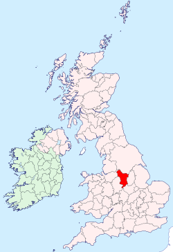
Derbyshire (/ˈdɑːrbiʃɪər, -ʃər/ DAR-bee-sheer, -shər)[4] is a ceremonial county in the East Midlands of England. It borders Greater Manchester, West Yorkshire, and South Yorkshire to the north, Nottinghamshire to the east, Leicestershire to the south-east, Staffordshire to the south and west, and Cheshire to the west. Derby is the largest settlement, and Matlock is the county town.
The county has an area of 2,625 km2 (1,014 sq mi) and a population of 1,053,316. The east of the county is more densely populated than the west, and contains the county's largest settlements: Derby (261,400), Chesterfield (88,483), and Swadlincote (45,000). For local government purposes Derbyshire comprises a non-metropolitan county, with eight districts, and the Derby unitary authority area. The East Midlands Combined County Authority includes Derbyshire County Council and Derby City Council.
The north and centre of Derbyshire are hilly and contain the southern end of the Pennines, most of which are part of the Peak District National Park. They include Kinder Scout, at 636 m (2,087 ft) the highest point in the county. The River Derwent is the longest in the county, at 66 miles (106 km), and flows south until it meets the River Trent just south of Derby. Church Flatts Farm at Coton in the Elms, near Swadlincote, is the furthest point from the sea in the UK.[5]
- ^ "Mid-2022 population estimates by Lieutenancy areas (as at 1997) for England and Wales". Office for National Statistics. 24 June 2024. Retrieved 26 June 2024.
- ^ "Derbyshire Demographics | Age, Ethnicity, Religion, Wellbeing". Varbes. Retrieved 10 February 2023.
- ^ "Mid-Year Population Estimates, UK, June 2022". Office for National Statistics. 26 March 2024. Retrieved 3 May 2024.
- ^ "Derbyshire". Collins English Dictionary. HarperCollins. Retrieved 29 May 2020.
- ^ "BBC report centre of England". 23 July 2003. Archived from the original on 6 March 2012. Retrieved 3 April 2011.


